Aadorf night lights from space
Night Light of Aadorf (Thurgau) from space (Switzerland) Src. Average luminocity for 10x10km area is 2.1349% and for 50x50km: 9.0984%.
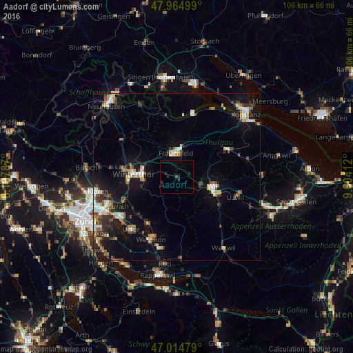
Analysis of Aadorf night lights 2016
Square area 10x10 km:
 0%
0%90-99
0%80-89
0%70-79
0%60-69
0%50-59
0%40-49
0.28%30-39
0.28%20-29
2.84%10-19
0%0-9
96.59%Square area 50x50 km:
1.04%90-99
1.49%80-89
0.8%70-79
0.97%60-69
1.13%50-59
0.98%40-49
1.43%30-39
1.44%20-29
2.03%10-19
6.81%0-9
81.89%Clear (daylight) street map image can be seen on geolist.org.
Map coordinates:
47° 57' 54" North, 8° 11' 52.3" East
47° 29' 31.3" North, 8° 54' 3.6" East
47° 0' 53.2" North, 9° 36' 14.8" East
Some cities around Aadorf sort by population:
• Frauenfeld
7.3 km =4.5 mi,  358°
358°
• Wil
11.4 km =7.1 mi,  107°
107°
• Oberwinterthur (Kreis 2)
10.3 km =6.4 mi,  285°
285°
• Seen (Kreis 3)
10 km =6.2 mi,  260°
260°
• Mattenbach (Kreis 7)
11.6 km =7.2 mi,  267°
267°
• Sirnach
8 km =5 mi, 114°
• Oberwinterthur (Kreis 2) / Guggenbühl
10.9 km =6.8 mi,  282°
282°
• Oberwinterthur (Kreis 2) / Talacker
11.3 km =7 mi, 277°
2661882 (p: 7,620)
Sources (retrieved 2019-11-25):
» Earth at Night: Flat Maps 2012, 2016