Wädenswil night lights from space
Night Light of Wädenswil (Zurich) from space (Switzerland) Src. Average luminocity for 10x10km area is 14.1295% and for 50x50km: 14.3658%.
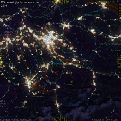
Analysis of Wädenswil night lights 2016
Square area 10x10 km:
 0%
0%90-99
0%80-89
2.23%70-79
1.19%60-69
4.17%50-59
2.68%40-49
4.17%30-39
3.42%20-29
2.83%10-19
2.08%0-9
77.23%Square area 50x50 km:
2.41%90-99
2.23%80-89
1.02%70-79
1.38%60-69
2.01%50-59
1.85%40-49
2.52%30-39
2.7%20-29
3.5%10-19
8.57%0-9
71.81%Clear (daylight) street map image can be seen on geolist.org.
Map coordinates:
47° 42' 7.8" North, 7° 57' 56.1" East
47° 13' 36.6" North, 8° 40' 7.3" East
46° 44' 49.9" North, 9° 22' 18.6" East
Some cities around Wädenswil sort by population:
• Horgen
6.5 km =4 mi,  304°
304°
• Freienbach
7.2 km =4.5 mi,  109°
109°
• Richterswil
3.1 km =1.9 mi,  137°
137°
• Männedorf
4 km =2.5 mi,  34°
34°
• Wollerau
5.2 km =3.2 mi,  133°
133°
• Horgen / Horgen (Dorfkern)
6 km =3.7 mi, 302°
• Stäfa
4.5 km =2.8 mi,  67°
67°
• Herrliberg
8.2 km =5.1 mi,  330°
330°
2658082 (p: 13,269)
Sources (retrieved 2019-11-25):
» Earth at Night: Flat Maps 2012, 2016