Männedorf night lights from space
Night Light of Männedorf (Zurich) from space (Switzerland) Src. Average luminocity for 10x10km area is 10.9033% and for 50x50km: 14.35%.
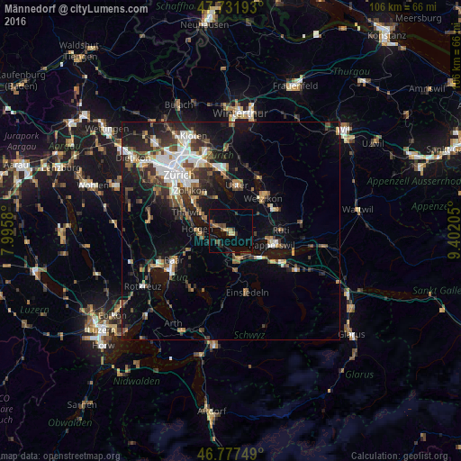
Analysis of Männedorf night lights 2016
Square area 10x10 km:
 0%
0%90-99
0%80-89
2.23%70-79
0.3%60-69
1.49%50-59
1.79%40-49
2.53%30-39
2.98%20-29
2.23%10-19
2.68%0-9
83.78%Square area 50x50 km:
2.43%90-99
2.24%80-89
0.94%70-79
1.31%60-69
1.85%50-59
1.84%40-49
2.55%30-39
2.61%20-29
3.8%10-19
9.32%0-9
71.1%Clear (daylight) street map image can be seen on geolist.org.
Map coordinates:
47° 43' 54.9" North, 7° 59' 44.9" East
47° 15' 24.7" North, 8° 41' 56.1" East
46° 46' 39" North, 9° 24' 7.4" East
Some cities around Männedorf sort by population:
• Horgen
7.6 km =4.7 mi,  272°
272°
• Freienbach
7.3 km =4.5 mi,  141°
141°
• Wädenswil
4 km =2.5 mi,  214°
214°
• Richterswil
5.6 km =3.5 mi,  181°
181°
• Wollerau
7.1 km =4.4 mi,  167°
167°
• Horgen / Horgen (Dorfkern)
7.3 km =4.5 mi, 269°
• Stäfa
2.4 km =1.5 mi,  130°
130°
• Herrliberg
7.4 km =4.6 mi,  300°
300°
2659772 (p: 7,951)
Sources (retrieved 2019-11-25):
» Earth at Night: Flat Maps 2012, 2016