Horgen night lights from space
Night Light of Horgen (Zurich) from space (Switzerland) Src. Average luminocity for 10x10km area is 16.4226% and for 50x50km: 17.2551%.
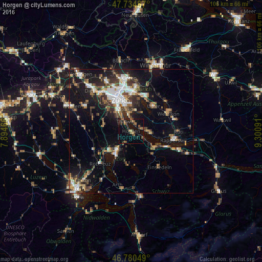
Analysis of Horgen night lights 2016
Square area 10x10 km:
 0%
0%90-99
0%80-89
0.6%70-79
0.89%60-69
5.36%50-59
4.32%40-49
2.68%30-39
3.13%20-29
5.65%10-19
16.82%0-9
60.57%Square area 50x50 km:
2.75%90-99
2.74%80-89
1.31%70-79
1.57%60-69
2.42%50-59
2.15%40-49
2.91%30-39
3.03%20-29
4.54%10-19
13.03%0-9
63.56%Clear (daylight) street map image can be seen on geolist.org.
Map coordinates:
47° 44' 5.5" North, 7° 53' 40.8" East
47° 15' 35.4" North, 8° 35' 52" East
46° 46' 49.8" North, 9° 18' 3.3" East
Some cities around Horgen sort by population:
• Adliswil
7.8 km =4.8 mi,  315°
315°
• Thalwil
4.4 km =2.7 mi, 323°
• Wädenswil
6.5 km =4 mi,  124°
124°
• Küsnacht
6.6 km =4.1 mi,  350°
350°
• Männedorf
7.6 km =4.7 mi,  92°
92°
• Langnau am Albis
5.4 km =3.4 mi,  307°
307°
• Thalwil / Dorfkern
4.2 km =2.6 mi,  325°
325°
• Herrliberg
3.7 km =2.3 mi,  20°
20°
2660305 (p: 15,973)
Sources (retrieved 2019-11-25):
» Earth at Night: Flat Maps 2012, 2016