Orbe night lights from space
Night Light of Orbe (Vaud) from space (Switzerland) Src. Average luminocity for 10x10km area is 8.6503% and for 50x50km: 8.516%.
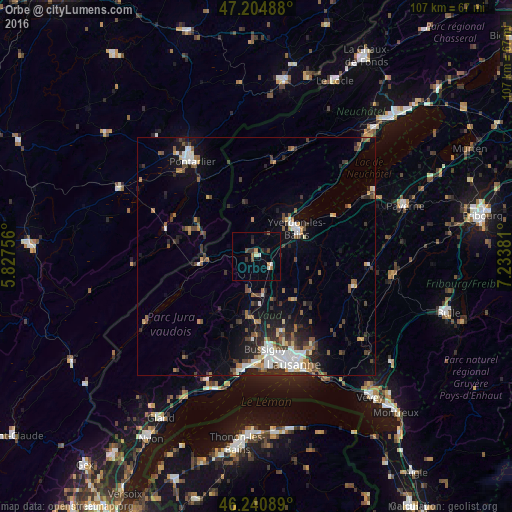
Analysis of Orbe night lights 2016
Square area 10x10 km:
 0.6%
0.6%90-99
1.49%80-89
0.3%70-79
1.19%60-69
0.74%50-59
1.19%40-49
0.74%30-39
2.98%20-29
0.89%10-19
1.49%0-9
88.39%Square area 50x50 km:
1.25%90-99
1.41%80-89
0.53%70-79
0.73%60-69
1.19%50-59
1.17%40-49
1.56%30-39
1.54%20-29
2.24%10-19
4.4%0-9
84.01%Clear (daylight) street map image can be seen on geolist.org.
Map coordinates:
47° 12' 17.6" North, 5° 49' 39.2" East
46° 43' 30.1" North, 6° 31' 50.5" East
46° 14' 27.2" North, 7° 14' 1.7" East
Some cities around Orbe sort by population:
• Yverdon-les-Bains
10.3 km =6.4 mi,  54°
54°
• Renens
21 km =13 mi,  167°
167°
• Prilly
21.7 km =13.5 mi,  164°
164°
• Colombier
19.2 km =11.9 mi,  193°
193°
• Bussigny
19.4 km =12.1 mi, 174°
• Crissier
20.2 km =12.6 mi, 170°
• Blécherette
21.8 km =13.5 mi, 161°
• Le Mont-sur-Lausanne
20.1 km =12.5 mi, 157°
2659289 (p: 5,132)
Sources (retrieved 2019-11-25):
» Earth at Night: Flat Maps 2012, 2016