Neuenhof night lights from space
Night Light of Neuenhof (Aargau) from space (Switzerland) Src. Average luminocity for 10x10km area is 30.8253% and for 50x50km: 17.2091%.
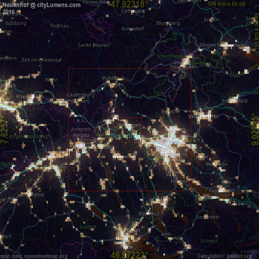
Analysis of Neuenhof night lights 2016
Square area 10x10 km:
 4.97%
4.97%90-99
4.69%80-89
2.98%70-79
1.28%60-69
5.68%50-59
1.7%40-49
5.82%30-39
4.12%20-29
4.97%10-19
53.27%0-9
10.51%Square area 50x50 km:
2.68%90-99
2.77%80-89
1.23%70-79
1.39%60-69
2.34%50-59
2.29%40-49
2.77%30-39
3%20-29
5.01%10-19
15.86%0-9
60.68%Clear (daylight) street map image can be seen on geolist.org.
Map coordinates:
47° 55' 23.4" North, 7° 37' 25.3" East
47° 26' 59.5" North, 8° 19' 36.6" East
46° 58' 20" North, 9° 1' 47.8" East
Some cities around Neuenhof sort by population:
• Dietikon
7.7 km =4.8 mi,  134°
134°
• Wettingen
2.4 km =1.5 mi,  341°
341°
• Baden
3 km =1.9 mi,  328°
328°
• Spreitenbach
4.3 km =2.7 mi, 134°
• Obersiggenthal
4.8 km =3 mi, 331°
• Windisch
8.8 km =5.5 mi,  291°
291°
• Untersiggenthal
7.9 km =4.9 mi,  317°
317°
• Würenlos
2.8 km =1.7 mi,  107°
107°
2659490 (p: 7,957)
Sources (retrieved 2019-11-25):
» Earth at Night: Flat Maps 2012, 2016