Würenlos night lights from space
Night Light of Würenlos (Aargau) from space (Switzerland) Src. Average luminocity for 10x10km area is 33.3196% and for 50x50km: 17.4534%.
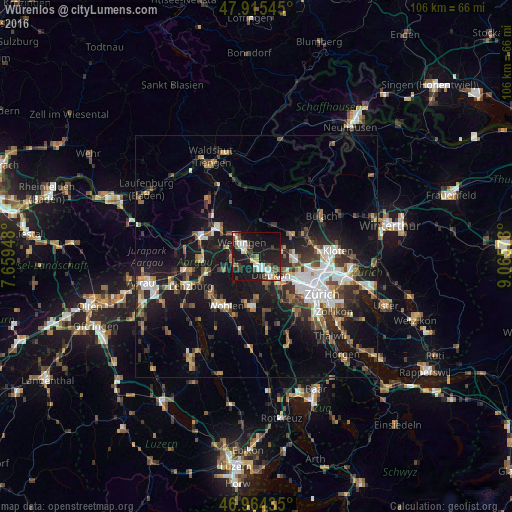
Analysis of Würenlos night lights 2016
Square area 10x10 km:
 6.25%
6.25%90-99
5.82%80-89
2.84%70-79
2.41%60-69
3.27%50-59
2.7%40-49
5.82%30-39
4.97%20-29
8.24%10-19
46.02%0-9
11.65%Square area 50x50 km:
2.71%90-99
2.79%80-89
1.27%70-79
1.41%60-69
2.36%50-59
2.33%40-49
2.89%30-39
3%20-29
4.8%10-19
16.24%0-9
60.2%Clear (daylight) street map image can be seen on geolist.org.
Map coordinates:
47° 54' 55.6" North, 7° 39' 34.1" East
47° 26' 31.4" North, 8° 21' 45.4" East
46° 57' 51.7" North, 9° 3' 56.6" East
Some cities around Würenlos sort by population:
• Dietikon
5.3 km =3.3 mi,  147°
147°
• Wettingen
4.7 km =2.9 mi,  312°
312°
• Baden
5.5 km =3.4 mi, 309°
• Spreitenbach
2.2 km =1.4 mi,  169°
169°
• Urdorf
7.9 km =4.9 mi,  143°
143°
• Obersiggenthal
7.1 km =4.4 mi,  315°
315°
• Neuenhof
2.8 km =1.7 mi,  287°
287°
• Regensdorf
8 km =5 mi,  96°
96°
2657947 (p: 5,497)
Sources (retrieved 2019-11-25):
» Earth at Night: Flat Maps 2012, 2016