Windisch night lights from space
Night Light of Windisch (Aargau) from space (Switzerland) Src. Average luminocity for 10x10km area is 24.3366% and for 50x50km: 15.7411%.
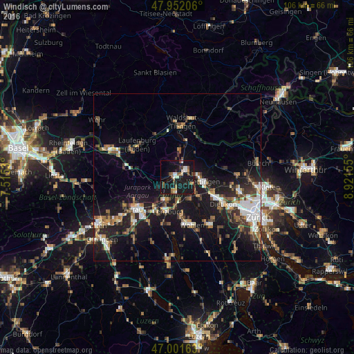
Analysis of Windisch night lights 2016
Square area 10x10 km:
 2.27%
2.27%90-99
4.69%80-89
1.85%70-79
0.99%60-69
3.41%50-59
3.98%40-49
2.13%30-39
2.13%20-29
4.12%10-19
52.7%0-9
21.73%Square area 50x50 km:
2.22%90-99
2.44%80-89
1.2%70-79
1.45%60-69
2.24%50-59
2.06%40-49
2.59%30-39
2.29%20-29
4.58%10-19
15.77%0-9
63.17%Clear (daylight) street map image can be seen on geolist.org.
Map coordinates:
47° 57' 7.4" North, 7° 30' 55.1" East
47° 28' 44.4" North, 8° 13' 6.3" East
47° 0' 5.9" North, 8° 55' 17.6" East
Some cities around Windisch sort by population:
• Wettingen
7.4 km =4.6 mi,  97°
97°
• Baden
6.6 km =4.1 mi, 95°
• Brugg
0.8 km =0.5 mi,  286°
286°
• Obersiggenthal
5.9 km =3.7 mi,  80°
80°
• Neuenhof
8.8 km =5.5 mi,  111°
111°
• Lenzburg
10.6 km =6.6 mi,  197°
197°
• Untersiggenthal
3.8 km =2.4 mi,  47°
47°
• Würenlos
11.6 km =7.2 mi, 110°
2657976 (p: 6,689)
Sources (retrieved 2019-11-25):
» Earth at Night: Flat Maps 2012, 2016