Baden night lights from space
Night Light of Baden (Aargau) from space (Switzerland) Src. Average luminocity for 10x10km area is 27.6264% and for 50x50km: 17.1181%.
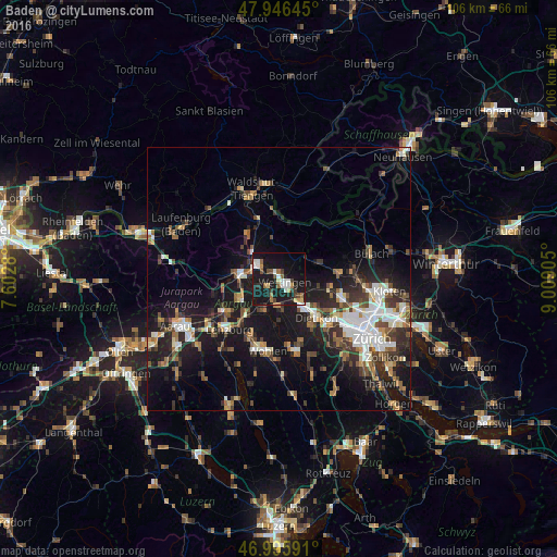
Analysis of Baden night lights 2016
Square area 10x10 km:
 3.69%
3.69%90-99
5.11%80-89
2.41%70-79
0.99%60-69
4.83%50-59
2.27%40-49
3.55%30-39
3.69%20-29
4.69%10-19
50.28%0-9
18.47%Square area 50x50 km:
2.71%90-99
2.86%80-89
1.25%70-79
1.35%60-69
2.27%50-59
2.27%40-49
2.8%30-39
2.95%20-29
4.8%10-19
15.92%0-9
60.82%Clear (daylight) street map image can be seen on geolist.org.
Map coordinates:
47° 56' 47.2" North, 7° 36' 10.1" East
47° 28' 24" North, 8° 18' 21.3" East
46° 59' 45.3" North, 9° 0' 32.6" East
Some cities around Baden sort by population:
• Wettingen
0.8 km =0.5 mi,  111°
111°
• Spreitenbach
7.3 km =4.5 mi,  140°
140°
• Brugg
7.4 km =4.6 mi,  276°
276°
• Obersiggenthal
1.7 km =1.1 mi,  335°
335°
• Neuenhof
3 km =1.9 mi,  148°
148°
• Windisch
6.6 km =4.1 mi, 275°
• Untersiggenthal
5 km =3.1 mi,  310°
310°
• Würenlos
5.5 km =3.4 mi,  129°
129°
2661646 (p: 16,118)
Sources (retrieved 2019-11-25):
» Earth at Night: Flat Maps 2012, 2016