Spreitenbach night lights from space
Night Light of Spreitenbach (Aargau) from space (Switzerland) Src. Average luminocity for 10x10km area is 35.0795% and for 50x50km: 17.7045%.
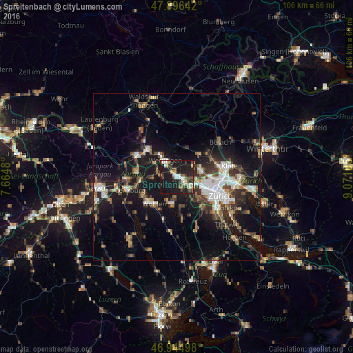
Analysis of Spreitenbach night lights 2016
Square area 10x10 km:
 5.97%
5.97%90-99
5.26%80-89
3.55%70-79
3.13%60-69
2.84%50-59
3.55%40-49
6.68%30-39
4.55%20-29
12.64%10-19
50%0-9
1.85%Square area 50x50 km:
2.71%90-99
2.77%80-89
1.3%70-79
1.48%60-69
2.47%50-59
2.31%40-49
2.9%30-39
2.99%20-29
4.87%10-19
16.67%0-9
59.54%Clear (daylight) street map image can be seen on geolist.org.
Map coordinates:
47° 53' 47.1" North, 7° 39' 53.3" East
47° 25' 22.3" North, 8° 22' 4.5" East
46° 56' 41.9" North, 9° 4' 15.8" East
Some cities around Spreitenbach sort by population:
• Dietikon
3.4 km =2.1 mi,  134°
134°
• Wettingen
6.6 km =4.1 mi,  323°
323°
• Baden
7.3 km =4.5 mi, 320°
• Schlieren
6.7 km =4.2 mi,  115°
115°
• Urdorf
6.1 km =3.8 mi, 133°
• Neuenhof
4.3 km =2.7 mi,  314°
314°
• Oberengstringen
7.5 km =4.7 mi,  102°
102°
• Würenlos
2.2 km =1.4 mi,  349°
349°
2658524 (p: 10,562)
Sources (retrieved 2019-11-25):
» Earth at Night: Flat Maps 2012, 2016