Marly night lights from space
Night Light of Marly (Fribourg) from space (Switzerland) Src. Average luminocity for 10x10km area is 23.4836% and for 50x50km: 7.2142%.
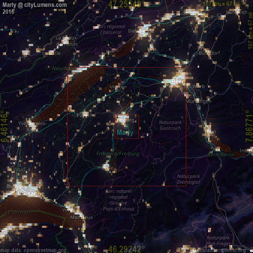
Analysis of Marly night lights 2016
Square area 10x10 km:
 5.36%
5.36%90-99
5.95%80-89
0.74%70-79
1.93%60-69
1.34%50-59
3.87%40-49
2.23%30-39
2.08%20-29
3.13%10-19
22.77%0-9
50.6%Square area 50x50 km:
0.93%90-99
1.2%80-89
0.59%70-79
0.67%60-69
0.72%50-59
1.04%40-49
1.27%30-39
0.95%20-29
2.01%10-19
4.97%0-9
85.66%Clear (daylight) street map image can be seen on geolist.org.
Map coordinates:
47° 15' 19.8" North, 6° 27' 41.3" East
46° 46' 34" North, 7° 9' 52.5" East
46° 17' 32.7" North, 7° 52' 3.8" East
Some cities around Marly sort by population:
• Köniz
25.2 km =15.7 mi,  49°
49°
• Fribourg
3.1 km =1.9 mi,  340°
340°
• Bulle
19.4 km =12.1 mi,  205°
205°
• Villars-sur-Glâne
4 km =2.5 mi,  293°
293°
• Payerne
18 km =11.2 mi, 286°
• Düdingen
8.4 km =5.2 mi,  14°
14°
• Murten/Morat
17.3 km =10.7 mi,  347°
347°
• Estavayer-le-Lac
25.5 km =15.8 mi, 288°
2659758 (p: 7,653)
Sources (retrieved 2019-11-25):
» Earth at Night: Flat Maps 2012, 2016