Köniz night lights from space
Night Light of Köniz (Bern) from space (Switzerland) Src. Average luminocity for 10x10km area is 41.9673% and for 50x50km: 9.546%.
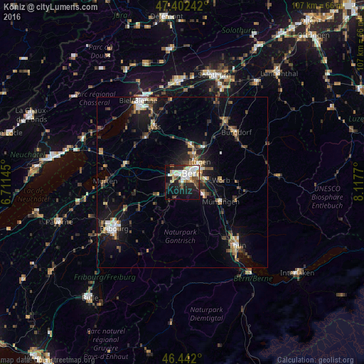

Analysis of Köniz night lights 2016
Square area 10x10 km:
100  7.59%
7.59%
90-99 13.24%
80-89 4.76%
70-79 3.57%
60-69 3.13%
50-59 3.13%
40-49 4.32%
30-39 3.13%
20-29 13.69%
10-19 27.83%
0-9 15.63%
7.59%90-99
13.24%80-89
4.76%70-79
3.57%60-69
3.13%50-59
3.13%40-49
4.32%30-39
3.13%20-29
13.69%10-19
27.83%0-9
15.63%Square area 50x50 km:
100 0.94%
90-99 1.42%
80-89 0.83%
70-79 0.86%
60-69 1.1%
50-59 1.47%
40-49 1.75%
30-39 1.58%
20-29 2.83%
10-19 7.95%
0-9 79.25%
0.94%90-99
1.42%80-89
0.83%70-79
0.86%60-69
1.1%50-59
1.47%40-49
1.75%30-39
1.58%20-29
2.83%10-19
7.95%0-9
79.25%Clear (daylight) street map image can be seen on geolist.org.
Map coordinates:
47° 24' 8.7" North, 6° 42' 41.2" East
46° 55' 27.7" North, 7° 24' 52.5" East
46° 26' 31.2" North, 8° 7' 3.7" East
Some cities around Köniz sort by population:
• Bern
3.6 km =2.2 mi,  43°
43°
• Muri
5.5 km =3.4 mi,  82°
82°
• Worb
11.3 km =7 mi,  86°
86°
• Münchenbuchsee
11.2 km =7 mi,  14°
14°
• Belp
7.3 km =4.5 mi,  120°
120°
• Wohlen
6.8 km =4.2 mi,  319°
319°
• Zollikofen
8.9 km =5.5 mi,  21°
21°
• Bolligen
8.4 km =5.2 mi,  47°
47°
2660119 (p: 37,196)
Sources (retrieved 2019-11-25):
» Earth at Night: Flat Maps 2012, 2016