Düdingen night lights from space
Night Light of Düdingen (Fribourg) from space (Switzerland) Src. Average luminocity for 10x10km area is 17.1637% and for 50x50km: 8.6709%.
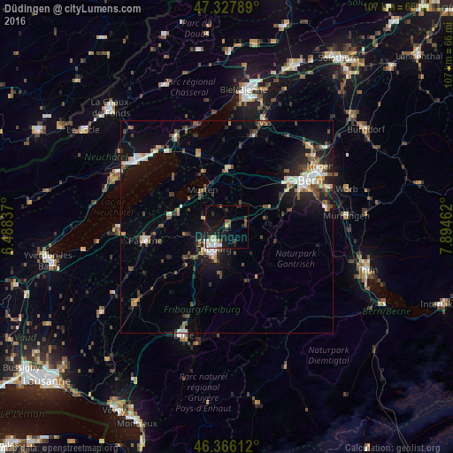
Analysis of Düdingen night lights 2016
Square area 10x10 km:
 2.98%
2.98%90-99
3.57%80-89
1.49%70-79
1.19%60-69
1.19%50-59
1.49%40-49
2.38%30-39
0.89%20-29
3.57%10-19
20.39%0-9
60.86%Square area 50x50 km:
1%90-99
1.36%80-89
0.7%70-79
0.78%60-69
0.91%50-59
1.28%40-49
1.53%30-39
1.2%20-29
2.5%10-19
6.64%0-9
82.1%Clear (daylight) street map image can be seen on geolist.org.
Map coordinates:
47° 19' 40.4" North, 6° 29' 18.1" East
46° 50' 57" North, 7° 11' 29.4" East
46° 21' 58" North, 7° 53' 40.6" East
Some cities around Düdingen sort by population:
• Bern
22.3 km =13.9 mi,  60°
60°
• Köniz
18.9 km =11.7 mi, 63°
• Fribourg
6 km =3.7 mi,  210°
210°
• Villars-sur-Glâne
8.6 km =5.3 mi,  220°
220°
• Wohlen
18.5 km =11.5 mi,  42°
42°
• Payerne
19.5 km =12.1 mi,  261°
261°
• Marly
8.4 km =5.2 mi,  194°
194°
• Murten/Morat
10.5 km =6.5 mi,  327°
327°
2660970 (p: 7,155)
Sources (retrieved 2019-11-25):
» Earth at Night: Flat Maps 2012, 2016