Brugg night lights from space
Night Light of Brugg (Aargau) from space (Switzerland) Src. Average luminocity for 10x10km area is 22.1151% and for 50x50km: 15.2122%.
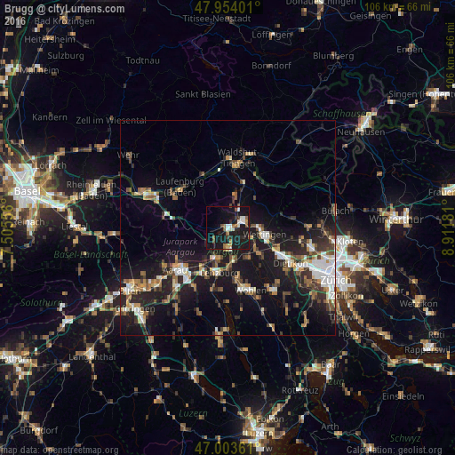
Analysis of Brugg night lights 2016
Square area 10x10 km:
 1.99%
1.99%90-99
4.69%80-89
0.99%70-79
0.99%60-69
3.13%50-59
3.98%40-49
1.85%30-39
2.13%20-29
4.12%10-19
44.89%0-9
31.25%Square area 50x50 km:
2.03%90-99
2.27%80-89
1.15%70-79
1.4%60-69
2.15%50-59
2.03%40-49
2.53%30-39
2.28%20-29
4.58%10-19
15.89%0-9
63.69%Clear (daylight) street map image can be seen on geolist.org.
Map coordinates:
47° 57' 14.4" North, 7° 30' 20" East
47° 28' 51.5" North, 8° 12' 31.3" East
47° 0' 13" North, 8° 54' 42.5" East
Some cities around Brugg sort by population:
• Wettingen
8.2 km =5.1 mi,  98°
98°
• Baden
7.4 km =4.6 mi, 96°
• Obersiggenthal
6.6 km =4.1 mi,  83°
83°
• Neuenhof
9.5 km =5.9 mi,  111°
111°
• Lenzburg
10.6 km =6.6 mi,  193°
193°
• Windisch
0.8 km =0.5 mi, 106°
• Untersiggenthal
4.2 km =2.6 mi,  56°
56°
• Würenlos
12.4 km =7.7 mi, 110°
2661374 (p: 9,196)
Sources (retrieved 2019-11-25):
» Earth at Night: Flat Maps 2012, 2016