Loango night lights from space
Night Light of Loango (Kouilou) from space (Republic of the Congo) Src. Average luminocity for 10x10km area is 25.75% and for 50x50km: 11.1732%.
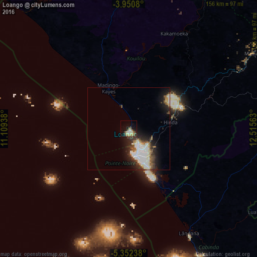
Analysis of Loango night lights 2016
Square area 10x10 km:
 1.86%
1.86%90-99
4.96%80-89
4.96%70-79
2.69%60-69
6.2%50-59
1.65%40-49
3.72%30-39
3.72%20-29
3.72%10-19
17.15%0-9
49.38%Square area 50x50 km:
2.52%90-99
3.11%80-89
0.88%70-79
0.58%60-69
0.92%50-59
1.06%40-49
1.35%30-39
1.7%20-29
3.16%10-19
6.05%0-9
78.66%Clear (daylight) street map image can be seen on geolist.org.
Map coordinates:
3° 57' 2.9" South, 11° 6' 33.8" East
4° 39' 7" South, 11° 48' 45" East
5° 21' 8.6" South, 12° 30' 56.3" East
Some cities around Loango sort by population:
• Pointe-Noire
14.9 km =9.3 mi,  157°
157°
• Dolisie
107.3 km =66.7 mi,  61°
61°
• Soio, AO
176 km =109.4 mi, 159°
• Cabinda, AO
108.7 km =67.5 mi, 156°
• Kayes
170.8 km =106.1 mi,  73°
73°
• Moanda, CD
154.7 km =96.1 mi, 156°
• Tshela, CD
131.6 km =81.8 mi,  106°
106°
• Loandjili
12.6 km =7.8 mi, 156°
2258375 (p: 0)
Sources (retrieved 2019-11-25):
» Earth at Night: Flat Maps 2012, 2016