Tottenham night lights from space
Night Light of Tottenham (Ontario) from space (Canada) Src. Average luminocity for 10x10km area is 5.3952% and for 50x50km: 13.5923%.
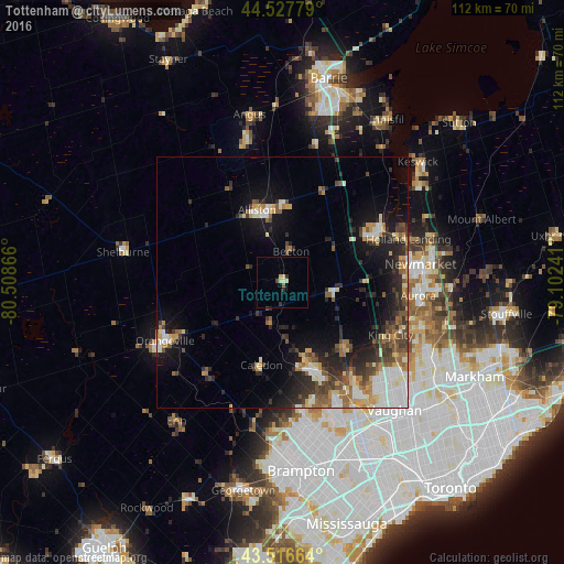
Analysis of Tottenham night lights 2016
Square area 10x10 km:
 0%
0%90-99
0.79%80-89
2.06%70-79
0.32%60-69
0%50-59
0.63%40-49
0.63%30-39
0.79%20-29
1.11%10-19
0.48%0-9
93.17%Square area 50x50 km:
1.98%90-99
2.24%80-89
1.46%70-79
1.74%60-69
1.43%50-59
2.06%40-49
2.22%30-39
2.22%20-29
4.09%10-19
7.47%0-9
73.08%Clear (daylight) street map image can be seen on geolist.org.
Map coordinates:
44° 31' 40" North, 80° 30' 31.2" West
44° 1' 27.7" North, 79° 48' 19.9" West
43° 30' 59.9" North, 79° 6' 8.7" West
Some cities around Tottenham sort by population:
• Vaughan
32.3 km =20.1 mi,  130°
130°
• Newmarket
27.3 km =17 mi,  83°
83°
• Aurora
27.3 km =17 mi,  95°
95°
• Orangeville
26.4 km =16.4 mi,  243°
243°
• East Gwillimbury
30.6 km =19 mi,  73°
73°
• Alliston
14.8 km =9.2 mi,  340°
340°
• Shelburne
32.4 km =20.1 mi,  280°
280°
• King
18.4 km =11.4 mi,  110°
110°
6167983 (p: 5,143)
Sources (retrieved 2019-11-25):
» Earth at Night: Flat Maps 2012, 2016