Princeville night lights from space
Night Light of Princeville (Quebec) from space (Canada) Src. Average luminocity for 10x10km area is 8.0128% and for 50x50km: 3.5802%.
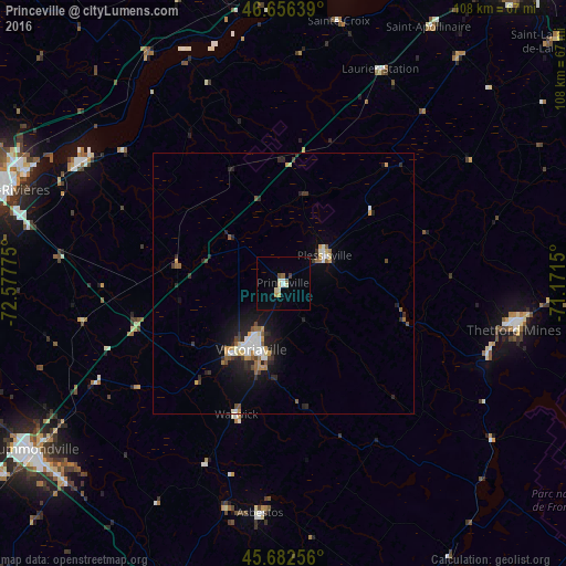
Analysis of Princeville night lights 2016
Square area 10x10 km:
 0.28%
0.28%90-99
2.41%80-89
1.42%70-79
0.85%60-69
0.14%50-59
1.14%40-49
0.71%30-39
0.43%20-29
0%10-19
0%0-9
92.61%Square area 50x50 km:
0.43%90-99
0.65%80-89
0.28%70-79
0.52%60-69
0.31%50-59
0.43%40-49
0.39%30-39
0.45%20-29
1.23%10-19
2.22%0-9
93.08%Clear (daylight) street map image can be seen on geolist.org.
Map coordinates:
46° 39' 23" North, 72° 34' 39.9" West
46° 10' 17.9" North, 71° 52' 28.6" West
45° 40' 57.2" North, 71° 10' 17.4" West
Some cities around Princeville sort by population:
• Trois-Rivières
55.2 km =34.3 mi,  290°
290°
• Drummondville
56.8 km =35.3 mi,  235°
235°
• Victoriaville
15.2 km =9.4 mi,  207°
207°
• Thetford-Mines
44.7 km =27.8 mi,  101°
101°
• Sainte-Catherine
55.6 km =34.5 mi, 287°
• Bécancour
46.8 km =29.1 mi, 293°
• Asbestos
45.2 km =28.1 mi,  185°
185°
• Plessisville
10.1 km =6.3 mi,  58°
58°
8379101 (p: 5,693)
Sources (retrieved 2019-11-25):
» Earth at Night: Flat Maps 2012, 2016