Leamington night lights from space
Night Light of Leamington (Ontario) from space (Canada) Src. Average luminocity for 10x10km area is 37.7825% and for 50x50km: 4.3621%.
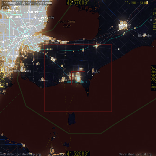

Analysis of Leamington night lights 2016
Square area 10x10 km:
 3.65%
3.65%90-99
6.35%80-89
7.62%70-79
4.76%60-69
4.29%50-59
4.44%40-49
4.13%30-39
9.84%20-29
10%10-19
31.75%0-9
13.17%Square area 50x50 km:
0.26%90-99
0.49%80-89
0.74%70-79
0.53%60-69
0.36%50-59
0.61%40-49
0.42%30-39
0.85%20-29
1.39%10-19
3.4%0-9
90.94%Clear (daylight) street map image can be seen on geolist.org.
Map coordinates:
42° 34' 12.2" North, 83° 18' 10.6" West
42° 3' 0.3" North, 82° 35' 59.3" West
41° 31' 33" North, 81° 53' 48.1" West
Some cities around Leamington sort by population:
• Detroit, US
48.3 km =30 mi,  310°
310°
• Windsor
44.2 km =27.5 mi, 308°
• Amherstburg
41.6 km =25.8 mi,  277°
277°
• Grosse Ile, US
45.8 km =28.5 mi, 281°
• Grosse Pointe Park, US
45.7 km =28.4 mi,  322°
322°
• Grosse Pointe Farms, US
46.6 km =29 mi,  328°
328°
• Essex
23.2 km =14.4 mi, 306°
• Grosse Pointe, US
45.3 km =28.1 mi, 325°
6051122 (p: 32,991)
Sources (retrieved 2019-11-25):
» Earth at Night: Flat Maps 2012, 2016