Grosse Pointe Park night lights from space
Night Light of Grosse Pointe Park (Michigan) from space (United States) Src. Average luminocity for 10x10km area is 78.6254% and for 50x50km: 53.927%.
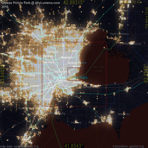
Analysis of Grosse Pointe Park night lights 2016
Square area 10x10 km:
 37.78%
90-99
16.98%80-89
9.84%70-79
6.83%60-69
3.02%50-59
2.22%40-49
5.87%30-39
9.37%20-29
8.1%10-19
0%0-9
0%Square area 50x50 km:
28.58%90-99
13.14%80-89
4.02%70-79
4.19%60-69
2.27%50-59
1.63%40-49
1.66%30-39
2.05%20-29
3.79%10-19
5.13%0-9
33.55%Clear (daylight) street map image can be seen on geolist.org.
Map coordinates:
42° 53' 35.3" North, 83° 38' 26" West
42° 22' 33.1" North, 82° 56' 14.7" West
41° 51' 15.5" North, 82° 14' 3.5" West
Some cities around Grosse Pointe Park sort by population:
• Detroit
10.2 km =6.3 mi,  240°
240°
• Windsor, CA
10.6 km =6.6 mi,  217°
217°
• Saint Clair Shores
14 km =8.7 mi,  16°
16°
• Roseville
13.5 km =8.4 mi,  0°
0°
• Eastpointe
10.4 km =6.5 mi,  351°
351°
• Hamtramck
9.4 km =5.8 mi,  281°
281°
• Harper Woods
6.5 km =4 mi,  9°
9°
• Highland Park
13.5 km =8.4 mi, 284°
4994868 (p: 11,220)
Sources (retrieved 2019-11-25):
» Earth at Night: Flat Maps 2012, 2016