Essex night lights from space
Night Light of Essex (Ontario) from space (Canada) Src. Average luminocity for 10x10km area is 11.5045% and for 50x50km: 21.5503%.
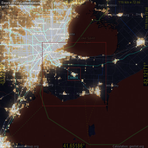
Analysis of Essex night lights 2016
Square area 10x10 km:
 1.21%
1.21%90-99
1.52%80-89
2.12%70-79
1.21%60-69
0.15%50-59
1.06%40-49
1.82%30-39
2.27%20-29
2.12%10-19
0.61%0-9
85.91%Square area 50x50 km:
7.97%90-99
4.2%80-89
1.88%70-79
1.96%60-69
1.51%50-59
1.79%40-49
1.73%30-39
2.24%20-29
3.84%10-19
7.26%0-9
65.63%Clear (daylight) street map image can be seen on geolist.org.
Map coordinates:
42° 41' 38.5" North, 83° 31' 40.7" West
42° 10' 30.3" North, 82° 49' 29.4" West
41° 39' 6.7" North, 82° 7' 18.2" West
Some cities around Essex sort by population:
• Detroit, US
25.2 km =15.7 mi,  313°
313°
• Windsor
21 km =13 mi, 311°
• Leamington
23.2 km =14.4 mi,  126°
126°
• Amherstburg
24.2 km =15 mi,  249°
249°
• Grosse Ile, US
26.8 km =16.7 mi,  259°
259°
• Grosse Pointe Park, US
24.2 km =15 mi,  337°
337°
• Grosse Pointe Farms, US
26.6 km =16.5 mi,  348°
348°
• Grosse Pointe, US
24.5 km =15.2 mi, 343°
5949531 (p: 7,446)
Sources (retrieved 2019-11-25):
» Earth at Night: Flat Maps 2012, 2016