Grosse Pointe night lights from space
Night Light of Grosse Pointe (Michigan) from space (United States) Src. Average luminocity for 10x10km area is 64.9619% and for 50x50km: 51.2408%.
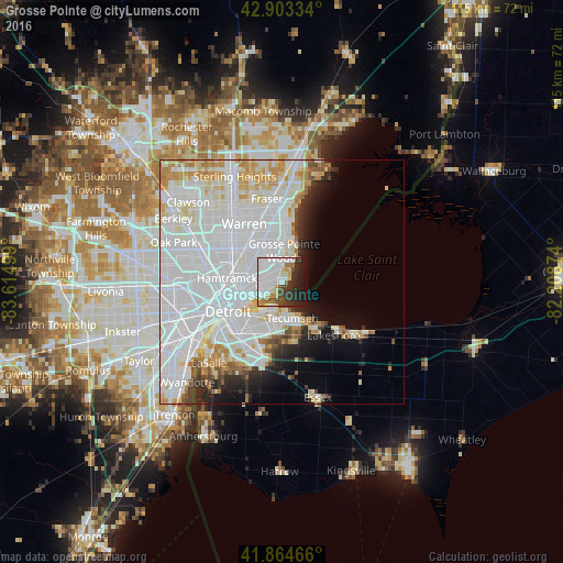
Analysis of Grosse Pointe night lights 2016
Square area 10x10 km:
 30%
30%90-99
14.13%80-89
4.6%70-79
4.6%60-69
3.97%50-59
1.59%40-49
5.4%30-39
8.41%20-29
13.81%10-19
13.49%0-9
0%Square area 50x50 km:
27.05%90-99
12.19%80-89
3.79%70-79
4.3%60-69
2.29%50-59
1.55%40-49
1.7%30-39
2%20-29
3.66%10-19
5.02%0-9
36.45%Clear (daylight) street map image can be seen on geolist.org.
Map coordinates:
42° 54' 12" North, 83° 36' 54" West
42° 23' 10.1" North, 82° 54' 42.7" West
41° 51' 52.8" North, 82° 12' 31.5" West
Some cities around Grosse Pointe sort by population:
• Detroit
12.6 km =7.8 mi,  241°
241°
• Windsor, CA
12.9 km =8 mi,  221°
221°
• Warren
14.3 km =8.9 mi,  324°
324°
• Saint Clair Shores
12.5 km =7.8 mi,  8°
8°
• Roseville
12.5 km =7.8 mi,  350°
350°
• Eastpointe
9.8 km =6.1 mi,  338°
338°
• Hamtramck
11.3 km =7 mi,  273°
273°
• Harper Woods
5.3 km =3.3 mi, 349°
4994862 (p: 5,232)
Sources (retrieved 2019-11-25):
» Earth at Night: Flat Maps 2012, 2016