Amherstburg night lights from space
Night Light of Amherstburg (Ontario) from space (Canada) Src. Average luminocity for 10x10km area is 25.4621% and for 50x50km: 34.9827%.
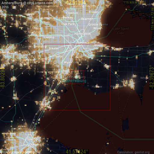
Analysis of Amherstburg night lights 2016
Square area 10x10 km:
 0.61%
0.61%90-99
5.3%80-89
1.97%70-79
3.64%60-69
2.42%50-59
4.24%40-49
6.06%30-39
4.09%20-29
11.52%10-19
21.52%0-9
38.64%Square area 50x50 km:
10.69%90-99
10.01%80-89
3.3%70-79
3.22%60-69
3.32%50-59
3.07%40-49
3.09%30-39
3.11%20-29
5.47%10-19
8.76%0-9
45.96%Clear (daylight) street map image can be seen on geolist.org.
Map coordinates:
42° 37' 10.7" North, 83° 48' 10.7" West
42° 6' 0.3" North, 83° 5' 59.5" West
41° 34' 34.5" North, 82° 23' 48.2" West
Some cities around Amherstburg sort by population:
• Southgate, US
14.8 km =9.2 mi,  328°
328°
• Wyandotte, US
13.3 km =8.3 mi,  341°
341°
• Trenton, US
7.8 km =4.8 mi,  304°
304°
• Woodhaven, US
12.5 km =7.8 mi,  290°
290°
• Riverview, US
10.5 km =6.5 mi,  321°
321°
• Grosse Ile, US
4.9 km =3 mi,  311°
311°
• Flat Rock, US
15.8 km =9.8 mi,  268°
268°
• Ecorse, US
16.5 km =10.3 mi,  346°
346°
5884472 (p: 13,910)
Sources (retrieved 2019-11-25):
» Earth at Night: Flat Maps 2012, 2016