Greater Napanee night lights from space
Night Light of Greater Napanee (Ontario) from space (Canada) Src. Average luminocity for 10x10km area is 10.7333% and for 50x50km: 1.3059%.
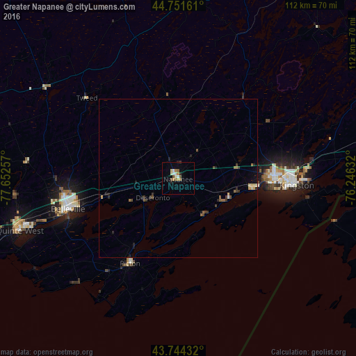
Analysis of Greater Napanee night lights 2016
Square area 10x10 km:
 1.21%
1.21%90-99
1.52%80-89
1.82%70-79
1.06%60-69
2.12%50-59
1.82%40-49
0.76%30-39
0.3%20-29
1.52%10-19
0.15%0-9
87.73%Square area 50x50 km:
0.06%90-99
0.12%80-89
0.19%70-79
0.1%60-69
0.23%50-59
0.23%40-49
0.22%30-39
0.29%20-29
0.38%10-19
0.22%0-9
97.96%Clear (daylight) street map image can be seen on geolist.org.
Map coordinates:
44° 45' 5.8" North, 77° 39' 9.3" West
44° 15' 0.4" North, 76° 56' 58" West
43° 44' 39.6" North, 76° 14' 46.8" West
Some cities around Greater Napanee sort by population:
• Kingston
37.4 km =23.2 mi,  93°
93°
• Belleville
35.8 km =22.2 mi,  254°
254°
• Quinte West
49.7 km =30.9 mi,  261°
261°
• Watertown, US
88.4 km =54.9 mi,  110°
110°
• Prince Edward
36.7 km =22.8 mi,  220°
220°
• Napanee
0 km =0 mi,  0°
0°
• Perth
91.1 km =56.6 mi,  37°
37°
• Gananoque
63 km =39.1 mi,  81°
81°
5965812 (p: 15,132)
Sources (retrieved 2019-11-25):
» Earth at Night: Flat Maps 2012, 2016