Gananoque night lights from space
Night Light of Gananoque (Ontario) from space (Canada) Src. Average luminocity for 10x10km area is 6.227% and for 50x50km: 1.6825%.
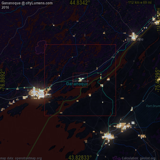
Analysis of Gananoque night lights 2016
Square area 10x10 km:
 0.79%
0.79%90-99
1.27%80-89
0.48%70-79
1.27%60-69
0.63%50-59
1.59%40-49
0.95%30-39
0%20-29
0%10-19
0.16%0-9
92.86%Square area 50x50 km:
0.1%90-99
0.33%80-89
0.25%70-79
0.22%60-69
0.15%50-59
0.23%40-49
0.25%30-39
0.16%20-29
0.5%10-19
0.98%0-9
96.82%Clear (daylight) street map image can be seen on geolist.org.
Map coordinates:
44° 50' 3.1" North, 76° 52' 9.1" West
44° 20' 0.3" North, 76° 9' 57.9" West
43° 49' 42" North, 75° 27' 46.6" West
Some cities around Gananoque sort by population:
• Kingston
27.6 km =17.1 mi,  245°
245°
• Watertown, US
44.8 km =27.8 mi,  152°
152°
• Brockville
47.6 km =29.6 mi,  52°
52°
• Greater Napanee
63 km =39.1 mi,  261°
261°
• Fort Drum, US
44.4 km =27.6 mi,  133°
133°
• Smiths Falls
64.5 km =40.1 mi,  10°
10°
• Napanee
63 km =39.1 mi, 261°
• Perth
63.4 km =39.4 mi,  354°
354°
5959326 (p: 5,458)
Sources (retrieved 2019-11-25):
» Earth at Night: Flat Maps 2012, 2016