Buckingham night lights from space
Night Light of Buckingham (Quebec) from space (Canada) Src. Average luminocity for 10x10km area is 23.1015% and for 50x50km: 13.867%.
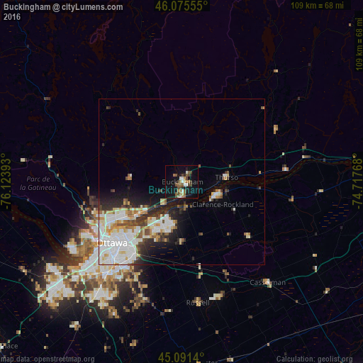
Analysis of Buckingham night lights 2016
Square area 10x10 km:
 2.58%
2.58%90-99
2.88%80-89
1.21%70-79
1.82%60-69
3.79%50-59
5.91%40-49
6.06%30-39
1.82%20-29
3.03%10-19
25.61%0-9
45.3%Square area 50x50 km:
3.88%90-99
3.37%80-89
1.5%70-79
1.17%60-69
0.98%50-59
1.44%40-49
1.38%30-39
1.47%20-29
2.81%10-19
5.21%0-9
76.79%Clear (daylight) street map image can be seen on geolist.org.
Map coordinates:
46° 4' 32" North, 76° 7' 26.1" West
45° 35' 8.3" North, 75° 25' 14.9" West
45° 5' 29" North, 74° 43' 3.6" West
Some cities around Buckingham sort by population:
• Ottawa
29 km =18 mi,  228°
228°
• Gatineau
25 km =15.5 mi,  241°
241°
• Fallingbrook
13.2 km =8.2 mi,  201°
201°
• Clarence-Rockland
10.8 km =6.7 mi,  111°
111°
• Vanier
25 km =15.5 mi, 229°
• Queenswood Heights
14.4 km =8.9 mi,  207°
207°
• Cantley
28.2 km =17.5 mi,  265°
265°
• Val-des-Monts
20.4 km =12.7 mi,  290°
290°
6942645 (p: 16,685)
Sources (retrieved 2019-11-25):
» Earth at Night: Flat Maps 2012, 2016