Cantley night lights from space
Night Light of Cantley (Quebec) from space (Canada) Src. Average luminocity for 10x10km area is 6.2864% and for 50x50km: 17.4515%.
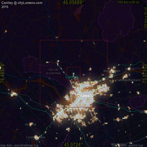
Analysis of Cantley night lights 2016
Square area 10x10 km:
 0%
0%90-99
0%80-89
0%70-79
0.61%60-69
0.45%50-59
0.15%40-49
1.52%30-39
4.39%20-29
4.24%10-19
6.21%0-9
82.42%Square area 50x50 km:
4.93%90-99
4.37%80-89
1.94%70-79
1.58%60-69
1.83%50-59
1.53%40-49
1.53%30-39
2.41%20-29
3.62%10-19
4.79%0-9
71.47%Clear (daylight) street map image can be seen on geolist.org.
Map coordinates:
46° 3' 24.8" North, 76° 29' 8.8" West
45° 34' 0.5" North, 75° 46' 57.5" West
45° 4' 20.6" North, 75° 4' 46.3" West
Some cities around Cantley sort by population:
• Ottawa
18.5 km =11.5 mi,  159°
159°
• Gatineau
11.8 km =7.3 mi,  147°
147°
• Nepean
26.1 km =16.2 mi,  169°
169°
• Fallingbrook
25.4 km =15.8 mi,  113°
113°
• Vanier
16.8 km =10.4 mi, 146°
• le Plateau
14.6 km =9.1 mi,  179°
179°
• Queenswood Heights
24.1 km =15 mi,  116°
116°
• Val-des-Monts
13 km =8.1 mi,  44°
44°
5915148 (p: 10,412)
Sources (retrieved 2019-11-25):
» Earth at Night: Flat Maps 2012, 2016