Solânea night lights from space
Night Light of Solânea (Paraíba) from space (Brazil) Src. Average luminocity for 10x10km area is 7.4134% and for 50x50km: 7.8543%.
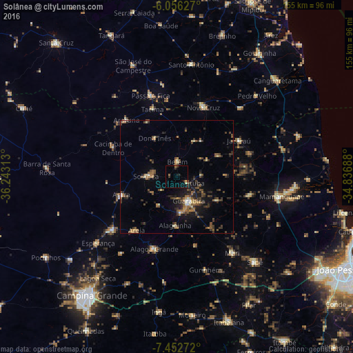
Analysis of Solânea night lights 2016
Square area 10x10 km:
 0%
0%90-99
0%80-89
1.3%70-79
1.73%60-69
0.87%50-59
0.43%40-49
0%30-39
2.81%20-29
1.08%10-19
4.33%0-9
87.45%Square area 50x50 km:
0.24%90-99
0.46%80-89
0.64%70-79
0.88%60-69
1.29%50-59
1.9%40-49
1.66%30-39
2.22%20-29
2.27%10-19
4.52%0-9
83.92%Clear (daylight) street map image can be seen on geolist.org.
Map coordinates:
6° 3' 22.6" South, 36° 14' 35.3" West
6° 45' 18" South, 35° 32' 24" West
7° 27' 9.8" South, 34° 50' 12.8" West
Some cities around Solânea sort by population:
• Guarabira
12.4 km =7.7 mi,  153°
153°
• Belém
7.1 km =4.4 mi,  5°
5°
• Areia
28.6 km =17.8 mi,  215°
215°
• Pirpirituba
5.3 km =3.3 mi,  121°
121°
• Arara
25.4 km =15.8 mi,  251°
251°
• Alagoinha
21.7 km =13.5 mi,  181°
181°
• Cacimba de Dentro
30.3 km =18.8 mi,  294°
294°
• Bananeiras
10.3 km =6.4 mi,  273°
273°
3387266 (p: 17,030)
Sources (retrieved 2019-11-25):
» Earth at Night: Flat Maps 2012, 2016