Belém night lights from space
Night Light of Belém (Paraíba) from space (Brazil) Src. Average luminocity for 10x10km area is 8.5303% and for 50x50km: 7.7049%.
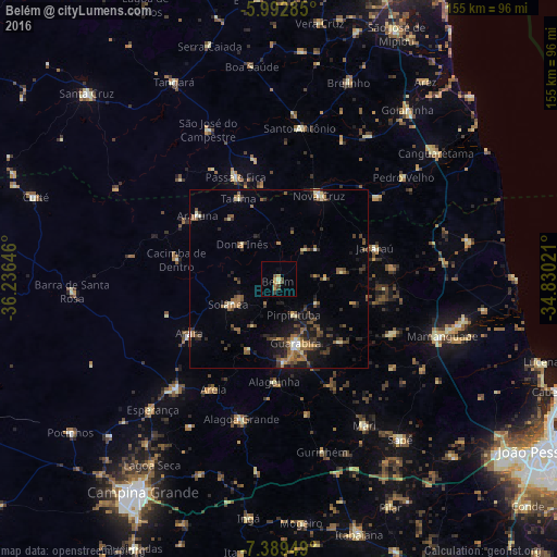
Analysis of Belém night lights 2016
Square area 10x10 km:
 0%
0%90-99
0%80-89
1.73%70-79
3.46%60-69
0.43%50-59
0.43%40-49
3.03%30-39
2.16%20-29
0%10-19
0%0-9
88.74%Square area 50x50 km:
0.24%90-99
0.6%80-89
0.8%70-79
0.77%60-69
1.26%50-59
1.75%40-49
1.6%30-39
1.85%20-29
2.28%10-19
4.05%0-9
84.8%Clear (daylight) street map image can be seen on geolist.org.
Map coordinates:
5° 59' 34.3" South, 36° 14' 11.3" West
6° 41' 30" South, 35° 31' 60" West
7° 23' 22.2" South, 34° 49' 48.8" West
Some cities around Belém sort by population:
• Guarabira
18.8 km =11.7 mi,  165°
165°
• Nova Cruz
26.2 km =16.3 mi,  24°
24°
• Solânea
7.1 km =4.4 mi,  185°
185°
• Pirpirituba
10.5 km =6.5 mi,  158°
158°
• Araruna
27.4 km =17 mi,  302°
302°
• Alagoinha
28.8 km =17.9 mi,  182°
182°
• Bananeiras
12.8 km =8 mi,  239°
239°
• Jacaraú
28 km =17.4 mi,  71°
71°
3405863 (p: 15,550)
Sources (retrieved 2019-11-25):
» Earth at Night: Flat Maps 2012, 2016