Areia night lights from space
Night Light of Areia (Paraíba) from space (Brazil) Src. Average luminocity for 10x10km area is 8.487% and for 50x50km: 8.535%.
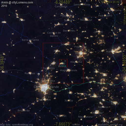
Analysis of Areia night lights 2016
Square area 10x10 km:
 0%
0%90-99
0%80-89
0%70-79
2.6%60-69
2.16%50-59
3.9%40-49
0.87%30-39
1.73%20-29
0.87%10-19
0.87%0-9
87.01%Square area 50x50 km:
0.32%90-99
0.63%80-89
0.72%70-79
0.8%60-69
1.8%50-59
2.26%40-49
1.38%30-39
1.83%20-29
2.65%10-19
4.71%0-9
82.9%Clear (daylight) street map image can be seen on geolist.org.
Map coordinates:
6° 15' 53.6" South, 36° 23' 41.3" West
6° 57' 48" South, 35° 41' 30" West
7° 39' 38.6" South, 34° 59' 18.8" West
Some cities around Areia sort by population:
• Guarabira
25.3 km =15.7 mi,  61°
61°
• Esperança
19.8 km =12.3 mi,  247°
247°
• Alagoa Grande
22.7 km =14.1 mi,  162°
162°
• Remígio
10 km =6.2 mi,  280°
280°
• Alagoa Nova
14 km =8.7 mi,  211°
211°
• Arara
16.7 km =10.4 mi,  333°
333°
• Alagoinha
16.3 km =10.1 mi,  84°
84°
• Bananeiras
24.6 km =15.3 mi,  15°
15°
3407210 (p: 13,824)
Sources (retrieved 2019-11-25):
» Earth at Night: Flat Maps 2012, 2016