Bananeiras night lights from space
Night Light of Bananeiras (Paraíba) from space (Brazil) Src. Average luminocity for 10x10km area is 14.6948% and for 50x50km: 7.7004%.
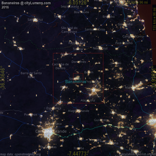
Analysis of Bananeiras night lights 2016
Square area 10x10 km:
 0.43%
0.43%90-99
1.52%80-89
0.65%70-79
0%60-69
7.36%50-59
4.76%40-49
2.38%30-39
0.22%20-29
0.87%10-19
1.3%0-9
80.52%Square area 50x50 km:
0.36%90-99
0.61%80-89
0.55%70-79
0.83%60-69
1.33%50-59
1.92%40-49
1.54%30-39
1.71%20-29
2.22%10-19
4.42%0-9
84.48%Clear (daylight) street map image can be seen on geolist.org.
Map coordinates:
6° 3' 4.5" South, 36° 20' 11.3" West
6° 45' 0" South, 35° 37' 60" West
7° 26' 51.8" South, 34° 55' 48.8" West
Some cities around Bananeiras sort by population:
• Guarabira
19.6 km =12.2 mi,  126°
126°
• Solânea
10.3 km =6.4 mi,  93°
93°
• Belém
12.8 km =8 mi,  59°
59°
• Pirpirituba
15.2 km =9.4 mi,  102°
102°
• Araruna
24.4 km =15.2 mi,  330°
330°
• Arara
16.3 km =10.1 mi,  237°
237°
• Alagoinha
24.3 km =15.1 mi,  156°
156°
• Cacimba de Dentro
21.1 km =13.1 mi,  304°
304°
3406503 (p: 7,371)
Sources (retrieved 2019-11-25):
» Earth at Night: Flat Maps 2012, 2016