Alagoinha night lights from space
Night Light of Alagoinha (Paraíba) from space (Brazil) Src. Average luminocity for 10x10km area is 8.7641% and for 50x50km: 8.0658%.
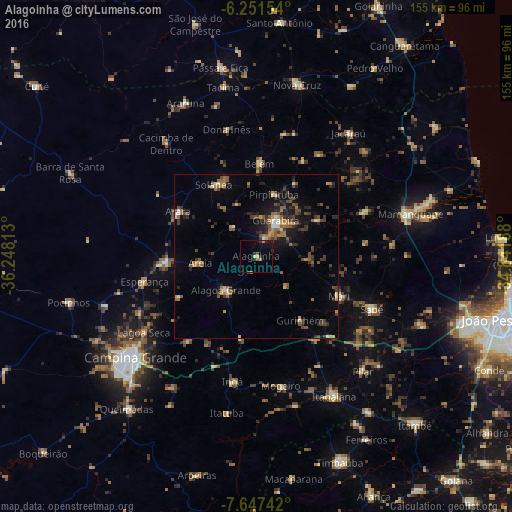
Analysis of Alagoinha night lights 2016
Square area 10x10 km:
 0%
0%90-99
1.3%80-89
0.43%70-79
1.3%60-69
0.87%50-59
1.73%40-49
0%30-39
2.38%20-29
3.25%10-19
6.71%0-9
82.03%Square area 50x50 km:
0.27%90-99
0.51%80-89
0.67%70-79
0.85%60-69
1.58%50-59
1.78%40-49
1.57%30-39
2.05%20-29
2.3%10-19
4.43%0-9
83.98%Clear (daylight) street map image can be seen on geolist.org.
Map coordinates:
6° 15' 5.5" South, 36° 14' 53.3" West
6° 57' 0" South, 35° 32' 42" West
7° 38' 50.7" South, 34° 50' 30.8" West
Some cities around Alagoinha sort by population:
• Guarabira
12.2 km =7.6 mi,  29°
29°
• Solânea
21.7 km =13.5 mi,  1°
1°
• Areia
16.3 km =10.1 mi,  264°
264°
• Remígio
26 km =16.2 mi,  270°
270°
• Pirpirituba
19.6 km =12.2 mi,  15°
15°
• Arara
27.2 km =16.9 mi,  299°
299°
• Bananeiras
24.3 km =15.1 mi,  336°
336°
• Gurinhém
23.5 km =14.6 mi,  145°
145°
3408094 (p: 7,474)
Sources (retrieved 2019-11-25):
» Earth at Night: Flat Maps 2012, 2016