Arara night lights from space
Night Light of Arara (Paraíba) from space (Brazil) Src. Average luminocity for 10x10km area is 12.9892% and for 50x50km: 4.7721%.
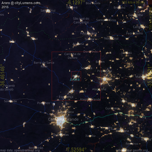
Analysis of Arara night lights 2016
Square area 10x10 km:
 1.95%
1.95%90-99
1.52%80-89
0%70-79
0%60-69
3.46%50-59
1.08%40-49
4.76%30-39
1.95%20-29
4.98%10-19
2.16%0-9
78.14%Square area 50x50 km:
0.17%90-99
0.42%80-89
0.3%70-79
0.39%60-69
1.1%50-59
1.18%40-49
0.93%30-39
0.75%20-29
0.96%10-19
1.56%0-9
92.24%Clear (daylight) street map image can be seen on geolist.org.
Map coordinates:
6° 7' 46.9" South, 36° 27' 41.3" West
6° 49' 42" South, 35° 45' 30" West
7° 31' 33.4" South, 35° 3' 18.8" West
Some cities around Arara sort by population:
• Esperança
25.2 km =15.7 mi,  205°
205°
• Solânea
25.4 km =15.8 mi,  71°
71°
• Areia
16.7 km =10.4 mi,  153°
153°
• Remígio
13.4 km =8.3 mi,  190°
190°
• Alagoa Nova
27 km =16.8 mi,  180°
180°
• Alagoinha
27.2 km =16.9 mi,  119°
119°
• Cacimba de Dentro
21 km =13 mi,  350°
350°
• Bananeiras
16.3 km =10.1 mi,  57°
57°
3407297 (p: 7,641)
Sources (retrieved 2019-11-25):
» Earth at Night: Flat Maps 2012, 2016