São Lourenço da Serra night lights from space
Night Light of São Lourenço da Serra (São Paulo) from space (Brazil) Src. Average luminocity for 10x10km area is 6.1349% and for 50x50km: 22.1264%.
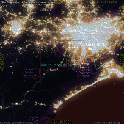
Analysis of São Lourenço da Serra night lights 2016
Square area 10x10 km:
 0%
0%90-99
0%80-89
1.19%70-79
1.19%60-69
0.79%50-59
0.2%40-49
3.37%30-39
1.79%20-29
0.99%10-19
0%0-9
90.48%Square area 50x50 km:
4.42%90-99
2.04%80-89
1.53%70-79
3.98%60-69
4.75%50-59
5.44%40-49
4.52%30-39
3.21%20-29
3.96%10-19
5.58%0-9
60.57%Clear (daylight) street map image can be seen on geolist.org.
Map coordinates:
23° 12' 28.2" South, 47° 38' 44.3" West
23° 51' 9" South, 46° 56' 33" West
24° 29' 38.3" South, 46° 14' 21.8" West
Some cities around São Lourenço da Serra sort by population:
• Embu
24.4 km =15.2 mi,  22°
22°
• Taboão da Serra
29.5 km =18.3 mi,  31°
31°
• Itapevi
33.8 km =21 mi,  1°
1°
• Cotia
27.7 km =17.2 mi, 4°
• Itapecerica da Serra
17.8 km =11.1 mi, 32°
• Embu Guaçu
13.5 km =8.4 mi,  80°
80°
• Ibiúna
35.9 km =22.3 mi,  307°
307°
• Juquitiba
15.5 km =9.6 mi,  235°
235°
3448599 (p: 13,330)
Sources (retrieved 2019-11-25):
» Earth at Night: Flat Maps 2012, 2016