Juquitiba night lights from space
Night Light of Juquitiba (São Paulo) from space (Brazil) Src. Average luminocity for 10x10km area is 7.3144% and for 50x50km: 4.7411%.
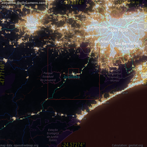
Analysis of Juquitiba night lights 2016
Square area 10x10 km:
 0.57%
0.57%90-99
0.19%80-89
0.95%70-79
0.38%60-69
2.27%50-59
1.7%40-49
2.08%30-39
0.57%20-29
1.33%10-19
0.95%0-9
89.02%Square area 50x50 km:
0.1%90-99
0.05%80-89
0.27%70-79
0.76%60-69
0.87%50-59
1.08%40-49
1.31%30-39
1.52%20-29
1.81%10-19
3.53%0-9
88.69%Clear (daylight) street map image can be seen on geolist.org.
Map coordinates:
23° 17' 14.6" South, 47° 46' 17.3" West
23° 55' 54" South, 47° 4' 6" West
24° 34' 21.9" South, 46° 21' 54.8" West
Some cities around Juquitiba sort by population:
• Embu
38.4 km =23.9 mi,  34°
34°
• Cotia
39.5 km =24.5 mi,  22°
22°
• Itapecerica da Serra
32.7 km =20.3 mi,  43°
43°
• Itanhaém
39.8 km =24.7 mi,  134°
134°
• Embu Guaçu
28.4 km =17.6 mi,  67°
67°
• Peruíbe
43.8 km =27.2 mi,  170°
170°
• Ibiúna
34.4 km =21.4 mi,  332°
332°
• São Lourenço da Serra
15.5 km =9.6 mi,  55°
55°
3459435 (p: 13,959)
Sources (retrieved 2019-11-25):
» Earth at Night: Flat Maps 2012, 2016