São José de Piranhas night lights from space
Night Light of São José de Piranhas (Paraíba) from space (Brazil) Src. Average luminocity for 10x10km area is 6.3442% and for 50x50km: 1.8819%.
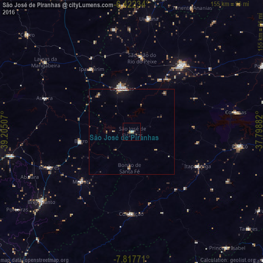
Analysis of São José de Piranhas night lights 2016
Square area 10x10 km:
 0.65%
0.65%90-99
1.08%80-89
0.87%70-79
1.73%60-69
0.87%50-59
0%40-49
1.73%30-39
0.87%20-29
0%10-19
0%0-9
92.21%Square area 50x50 km:
0.14%90-99
0.28%80-89
0.14%70-79
0.29%60-69
0.21%50-59
0.4%40-49
0.44%30-39
0.22%20-29
0.35%10-19
1.06%0-9
96.49%Clear (daylight) street map image can be seen on geolist.org.
Map coordinates:
6° 25' 20.4" South, 39° 12' 18.3" West
7° 7' 14" South, 38° 30' 7" West
7° 49' 3.8" South, 37° 47' 55.8" West
Some cities around São José de Piranhas sort by population:
• Sousa
50.3 km =31.3 mi,  36°
36°
• Cajazeiras
26.3 km =16.3 mi,  347°
347°
• Itaporanga
43.8 km =27.2 mi,  117°
117°
• Milagres
53.4 km =33.2 mi,  246°
246°
• Coremas
62.5 km =38.8 mi,  79°
79°
• Barro
60.3 km =37.5 mi,  318°
318°
• Aurora
55.1 km =34.2 mi,  291°
291°
• Juàzeirinho
60.2 km =37.4 mi,  55°
55°
3388442 (p: 7,628)
Sources (retrieved 2019-11-25):
» Earth at Night: Flat Maps 2012, 2016