Milagres night lights from space
Night Light of Milagres (Ceará) from space (Brazil) Src. Average luminocity for 10x10km area is 12.9177% and for 50x50km: 4.6068%.
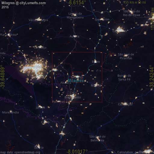
Analysis of Milagres night lights 2016
Square area 10x10 km:
 1.73%
1.73%90-99
1.73%80-89
0.43%70-79
2.6%60-69
1.3%50-59
2.81%40-49
1.52%30-39
1.73%20-29
3.03%10-19
0%0-9
83.12%Square area 50x50 km:
0.47%90-99
0.55%80-89
0.31%70-79
0.42%60-69
0.87%50-59
1.09%40-49
0.57%30-39
0.84%20-29
0.76%10-19
1.23%0-9
92.87%Clear (daylight) street map image can be seen on geolist.org.
Map coordinates:
6° 36' 55.4" South, 39° 38' 55.3" West
7° 18' 48" South, 38° 56' 44" West
8° 0' 36.6" South, 38° 14' 32.8" West
Some cities around Milagres sort by population:
• Juazeiro do Norte
42.3 km =26.3 mi,  285°
285°
• Crato
51.9 km =32.2 mi,  279°
279°
• Barbalha
39.6 km =24.6 mi,  270°
270°
• Brejo Santo
20.5 km =12.7 mi,  192°
192°
• Missão Velha
22.9 km =14.2 mi, 287°
• Caririaçu
48 km =29.8 mi,  308°
308°
• Aurora
41.3 km =25.7 mi,  356°
356°
• São José de Piranhas
53.4 km =33.2 mi,  66°
66°
3394884 (p: 12,588)
Sources (retrieved 2019-11-25):
» Earth at Night: Flat Maps 2012, 2016