Santa Cruz Cabrália night lights from space
Night Light of Santa Cruz Cabrália (Bahia) from space (Brazil) Src. Average luminocity for 10x10km area is 18.1798% and for 50x50km: 4.304%.
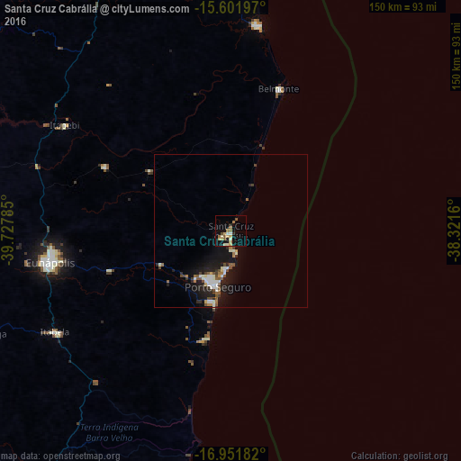
Analysis of Santa Cruz Cabrália night lights 2016
Square area 10x10 km:
 0.83%
0.83%90-99
3.31%80-89
3.72%70-79
2.07%60-69
3.51%50-59
3.93%40-49
0.83%30-39
0%20-29
2.27%10-19
12.4%0-9
67.15%Square area 50x50 km:
0.55%90-99
0.86%80-89
0.35%70-79
0.22%60-69
0.59%50-59
0.7%40-49
0.65%30-39
0.31%20-29
1%10-19
4.66%0-9
90.1%Clear (daylight) street map image can be seen on geolist.org.
Map coordinates:
15° 36' 7.1" South, 39° 43' 40.3" West
16° 16' 41" South, 39° 1' 29" West
16° 57' 6.6" South, 38° 19' 17.8" West
Some cities around Santa Cruz Cabrália sort by population:
• Porto Seguro
19.6 km =12.2 mi,  192°
192°
• Eunápolis
60.3 km =37.5 mi,  259°
259°
• Itamaraju
100.4 km =62.4 mi,  212°
212°
• Canavieiras
67.6 km =42 mi,  7°
7°
• Una
109.6 km =68.1 mi,  357°
357°
• Mascote
84.9 km =52.8 mi,  339°
339°
• Belmonte
48.9 km =30.4 mi,  18°
18°
• Guaratinga
87.7 km =54.5 mi,  247°
247°
3450288 (p: 19,545)
Sources (retrieved 2019-11-25):
» Earth at Night: Flat Maps 2012, 2016