Riolândia night lights from space
Night Light of Riolândia (São Paulo) from space (Brazil) Src. Average luminocity for 10x10km area is 5.6845% and for 50x50km: 0.8429%.
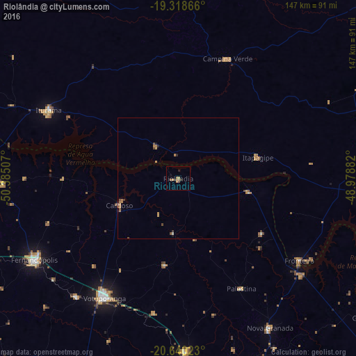
Analysis of Riolândia night lights 2016
Square area 10x10 km:
 0%
0%90-99
0%80-89
0%70-79
2.38%60-69
2.98%50-59
0.4%40-49
0.6%30-39
1.59%20-29
0.79%10-19
0.79%0-9
90.48%Square area 50x50 km:
0.03%90-99
0.03%80-89
0.02%70-79
0.31%60-69
0.34%50-59
0.12%40-49
0.15%30-39
0.1%20-29
0.13%10-19
0.13%0-9
98.63%Clear (daylight) street map image can be seen on geolist.org.
Map coordinates:
19° 19' 7.2" South, 50° 23' 6.3" West
19° 58' 51" South, 49° 40' 55" West
20° 38' 24.8" South, 48° 58' 43.8" West
Some cities around Riolândia sort by population:
• Votuporanga
57.8 km =35.9 mi,  211°
211°
• Fernandópolis
67.9 km =42.2 mi,  240°
240°
• Frutal
77.6 km =48.2 mi,  93°
93°
• Iturama
60.6 km =37.7 mi,  297°
297°
• Tanabi
71.9 km =44.7 mi,  177°
177°
• Nova Granada
72.5 km =45 mi,  148°
148°
• Campina Verde
53.3 km =33.1 mi,  22°
22°
• Cardoso
26.7 km =16.6 mi,  245°
245°
3451131 (p: 10,575)
Sources (retrieved 2019-11-25):
» Earth at Night: Flat Maps 2012, 2016