Riacho de Santana night lights from space
Night Light of Riacho de Santana (Bahia) from space (Brazil) Src. Average luminocity for 10x10km area is 7.4607% and for 50x50km: 0.6097%.
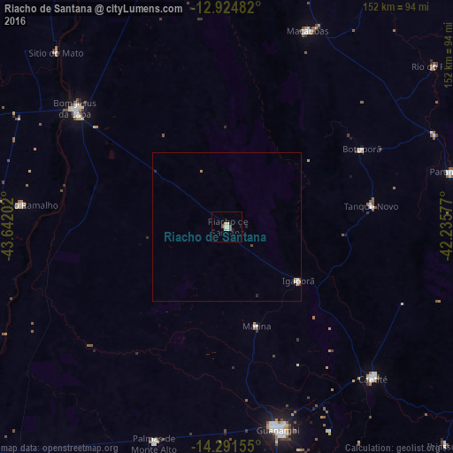
Analysis of Riacho de Santana night lights 2016
Square area 10x10 km:
 0.83%
0.83%90-99
1.65%80-89
1.65%70-79
0.83%60-69
0.21%50-59
2.27%40-49
0%30-39
0%20-29
0.21%10-19
1.03%0-9
91.32%Square area 50x50 km:
0.07%90-99
0.13%80-89
0.1%70-79
0.09%60-69
0.05%50-59
0.12%40-49
0.07%30-39
0%20-29
0.09%10-19
0.11%0-9
99.17%Clear (daylight) street map image can be seen on geolist.org.
Map coordinates:
12° 55' 29.4" South, 43° 38' 31.3" West
13° 36' 33" South, 42° 56' 20" West
14° 17' 29.6" South, 42° 14' 8.8" West
Some cities around Riacho de Santana sort by population:
• Guanambi
70.4 km =43.7 mi,  166°
166°
• Bom Jesus da Lapa
65.1 km =40.5 mi,  307°
307°
• Caetité
71.6 km =44.5 mi,  135°
135°
• Macaúbas
70.5 km =43.8 mi,  21°
21°
• Paratinga
105.5 km =65.6 mi,  345°
345°
• Paramirim
77.9 km =48.4 mi,  76°
76°
• Palmas de Monte Alto
77 km =47.8 mi,  198°
198°
• Boquira
90.3 km =56.1 mi,  14°
14°
3451448 (p: 12,657)
Sources (retrieved 2019-11-25):
» Earth at Night: Flat Maps 2012, 2016