Riachão do Jacuípe night lights from space
Night Light of Riachão do Jacuípe (Bahia) from space (Brazil) Src. Average luminocity for 10x10km area is 16.7707% and for 50x50km: 2.282%.
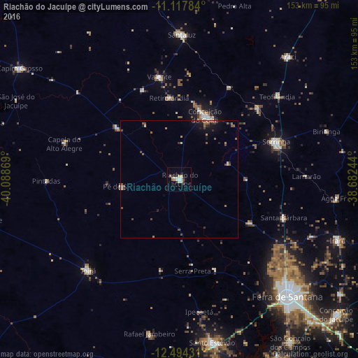
Analysis of Riachão do Jacuípe night lights 2016
Square area 10x10 km:
 1.86%
1.86%90-99
5.17%80-89
2.27%70-79
1.45%60-69
0.83%50-59
1.65%40-49
0.83%30-39
2.48%20-29
0.83%10-19
4.75%0-9
77.89%Square area 50x50 km:
0.11%90-99
0.38%80-89
0.09%70-79
0.22%60-69
0.35%50-59
0.6%40-49
0.38%30-39
0.44%20-29
0.36%10-19
1.15%0-9
95.93%Clear (daylight) street map image can be seen on geolist.org.
Map coordinates:
11° 7' 4.2" South, 40° 5' 19.3" West
11° 48' 25" South, 39° 23' 8" West
12° 29' 39.5" South, 38° 40' 56.8" West
Some cities around Riachão do Jacuípe sort by population:
• Feira de Santana
68.5 km =42.6 mi,  138°
138°
• Serrinha
44.1 km =27.4 mi,  68°
68°
• Conceição do Coité
29.3 km =18.2 mi,  22°
22°
• Ipirá
54.7 km =34 mi,  224°
224°
• Santaluz
61.3 km =38.1 mi,  1°
1°
• Araci
69.7 km =43.3 mi,  40°
40°
• Valente
44.7 km =27.8 mi,  349°
349°
• Anguera
41.2 km =25.6 mi,  158°
158°
3451474 (p: 16,911)
Sources (retrieved 2019-11-25):
» Earth at Night: Flat Maps 2012, 2016