Raposos night lights from space
Night Light of Raposos (Minas Gerais) from space (Brazil) Src. Average luminocity for 10x10km area is 32.0952% and for 50x50km: 33.2962%.
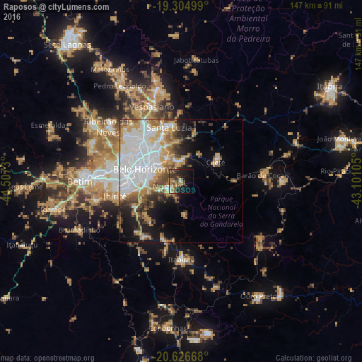
Analysis of Raposos night lights 2016
Square area 10x10 km:
 1.95%
1.95%90-99
1.95%80-89
3.03%70-79
4.55%60-69
7.58%50-59
5.19%40-49
10.61%30-39
8.66%20-29
9.31%10-19
23.59%0-9
23.59%Square area 50x50 km:
12.07%90-99
5.14%80-89
2.62%70-79
5.69%60-69
3.8%50-59
2.79%40-49
4.25%30-39
2.82%20-29
3.51%10-19
8.89%0-9
48.43%Clear (daylight) street map image can be seen on geolist.org.
Map coordinates:
19° 18' 18" South, 44° 30' 26.3" West
19° 58' 2" South, 43° 48' 15" West
20° 37' 36" South, 43° 6' 3.8" West
Some cities around Raposos sort by population:
• Belo Horizonte
14.9 km =9.3 mi,  290°
290°
• Contagem
26.4 km =16.4 mi,  278°
278°
• Santa Luzia
22.5 km =14 mi,  347°
347°
• Ibirité
27.3 km =17 mi,  257°
257°
• Vespasiano
33 km =20.5 mi,  337°
337°
• Nova Lima
4.9 km =3 mi,  245°
245°
• Itabirito
31.8 km =19.8 mi,  179°
179°
• Caeté
17.1 km =10.6 mi,  55°
55°
3451812 (p: 13,262)
Sources (retrieved 2019-11-25):
» Earth at Night: Flat Maps 2012, 2016