Pitimbu night lights from space
Night Light of Pitimbu (Paraíba) from space (Brazil) Src. Average luminocity for 10x10km area is 19.6537% and for 50x50km: 10.9146%.
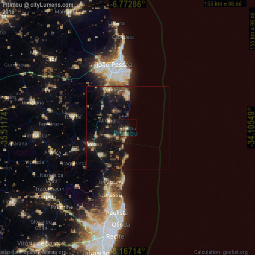
Analysis of Pitimbu night lights 2016
Square area 10x10 km:
 0.43%
0.43%90-99
0.87%80-89
3.9%70-79
0%60-69
6.28%50-59
4.11%40-49
3.03%30-39
5.41%20-29
4.11%10-19
14.72%0-9
57.14%Square area 50x50 km:
0.21%90-99
0.44%80-89
2.17%70-79
1.05%60-69
1.29%50-59
2.06%40-49
2.64%30-39
2.19%20-29
2.6%10-19
14.05%0-9
71.28%Clear (daylight) street map image can be seen on geolist.org.
Map coordinates:
6° 46' 22.3" South, 35° 30' 42.3" West
7° 28' 14" South, 34° 48' 31" West
8° 10' 1.7" South, 34° 6' 19.8" West
Some cities around Pitimbu sort by population:
• Goiana
23.6 km =14.7 mi,  244°
244°
• Condado
35.2 km =21.9 mi,  248°
248°
• Itapissuma
35.2 km =21.9 mi,  195°
195°
• Conde
25.9 km =16.1 mi,  335°
335°
• Itamaracá
30.9 km =19.2 mi,  183°
183°
• Pedras de Fogo
34.8 km =21.6 mi,  282°
282°
• Caaporã
12.1 km =7.5 mi, 245°
• Alhandra
12.2 km =7.6 mi,  286°
286°
3391889 (p: 7,862)
Sources (retrieved 2019-11-25):
» Earth at Night: Flat Maps 2012, 2016