Pedras de Fogo night lights from space
Night Light of Pedras de Fogo (Paraíba) from space (Brazil) Src. Average luminocity for 10x10km area is 20.1667% and for 50x50km: 14.3867%.
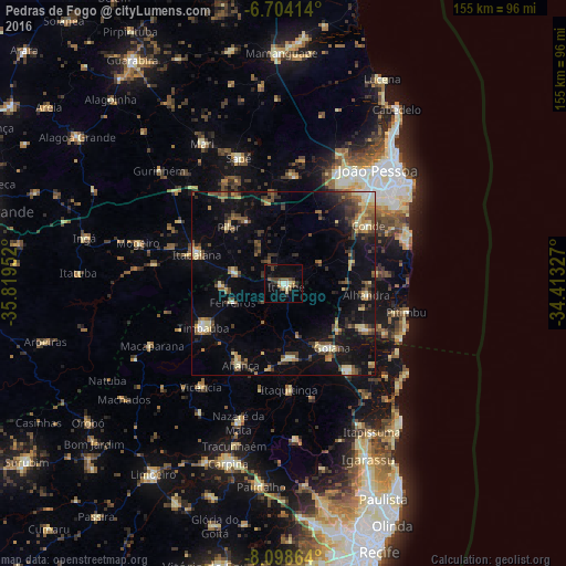
Analysis of Pedras de Fogo night lights 2016
Square area 10x10 km:
 1.52%
1.52%90-99
3.03%80-89
3.25%70-79
1.73%60-69
0.65%50-59
4.55%40-49
4.76%30-39
2.38%20-29
3.68%10-19
10.17%0-9
64.29%Square area 50x50 km:
0.53%90-99
1.16%80-89
2.57%70-79
1.21%60-69
1.68%50-59
2.95%40-49
2.79%30-39
2.95%20-29
3.26%10-19
11.12%0-9
69.78%Clear (daylight) street map image can be seen on geolist.org.
Map coordinates:
6° 42' 14.9" South, 35° 49' 10.3" West
7° 24' 7" South, 35° 6' 59" West
8° 5' 55.1" South, 34° 24' 47.8" West
Some cities around Pedras de Fogo sort by population:
• Timbaúba
25.1 km =15.6 mi,  242°
242°
• Goiana
21.6 km =13.4 mi,  144°
144°
• Condado
20.5 km =12.7 mi,  176°
176°
• Itabaiana
25.2 km =15.7 mi,  288°
288°
• Caaporã
26.2 km =16.3 mi,  118°
118°
• Alhandra
22.6 km =14 mi,  100°
100°
• Juripiranga
13.8 km =8.6 mi,  283°
283°
• Pilar
21.8 km =13.5 mi,  313°
313°
3392478 (p: 13,894)
Sources (retrieved 2019-11-25):
» Earth at Night: Flat Maps 2012, 2016