Itapissuma night lights from space
Night Light of Itapissuma (Pernambuco) from space (Brazil) Src. Average luminocity for 10x10km area is 51.1901% and for 50x50km: 22.7694%.
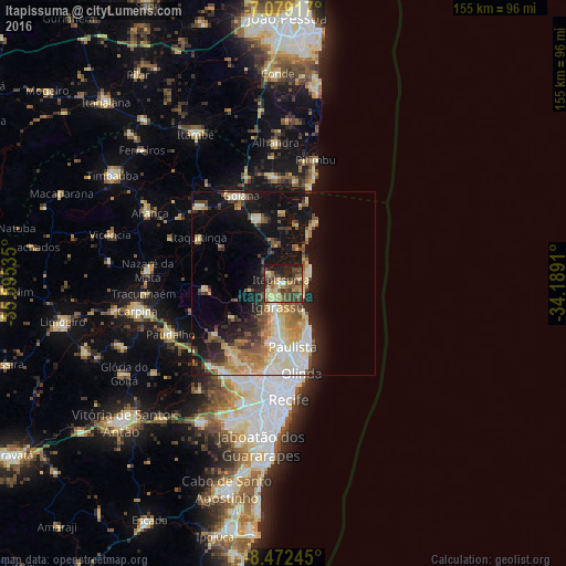
Analysis of Itapissuma night lights 2016
Square area 10x10 km:
 1.03%
1.03%90-99
1.45%80-89
16.12%70-79
8.47%60-69
9.09%50-59
11.16%40-49
16.53%30-39
13.84%20-29
10.95%10-19
11.36%0-9
0%Square area 50x50 km:
2.31%90-99
3.42%80-89
5.29%70-79
2.77%60-69
3.18%50-59
3.46%40-49
3.22%30-39
2.86%20-29
5.04%10-19
13.49%0-9
54.95%Clear (daylight) street map image can be seen on geolist.org.
Map coordinates:
7° 4' 45" South, 35° 35' 43.3" West
7° 46' 35" South, 34° 53' 32" West
8° 28' 20.8" South, 34° 11' 20.8" West
Some cities around Itapissuma sort by population:
• Olinda
26.2 km =16.3 mi,  171°
171°
• Paulista
18.4 km =11.4 mi, 173°
• Igarassu
6.6 km =4.1 mi,  193°
193°
• Abreu e Lima
15.1 km =9.4 mi,  184°
184°
• Goiana
26.9 km =16.7 mi,  333°
333°
• Itamaracá
8 km =5 mi,  66°
66°
• Araçoiaba
21.9 km =13.6 mi,  265°
265°
• Itaquitinga
26 km =16.2 mi,  297°
297°
3397904 (p: 16,673)
Sources (retrieved 2019-11-25):
» Earth at Night: Flat Maps 2012, 2016