Itamaracá night lights from space
Night Light of Itamaracá (Pernambuco) from space (Brazil) Src. Average luminocity for 10x10km area is 30.7169% and for 50x50km: 18.6128%.
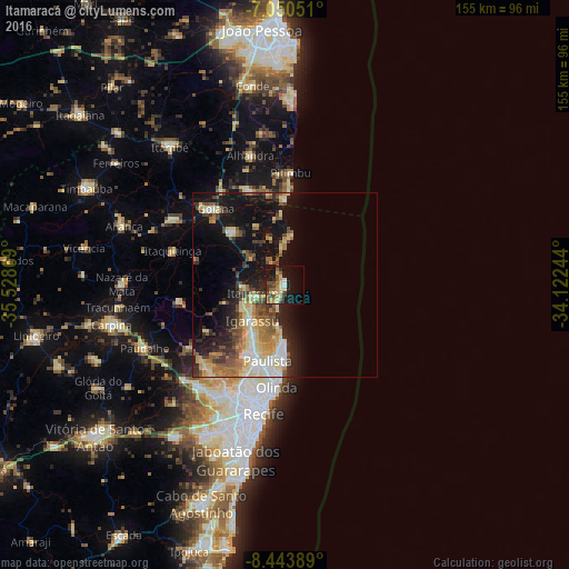
Analysis of Itamaracá night lights 2016
Square area 10x10 km:
 1.45%
1.45%90-99
1.86%80-89
7.64%70-79
4.34%60-69
5.58%50-59
6.4%40-49
5.58%30-39
4.34%20-29
3.31%10-19
31.4%0-9
28.1%Square area 50x50 km:
1.7%90-99
2.28%80-89
4.18%70-79
2.26%60-69
2.8%50-59
3.12%40-49
2.81%30-39
2.64%20-29
4.34%10-19
13.67%0-9
60.19%Clear (daylight) street map image can be seen on geolist.org.
Map coordinates:
7° 3' 1.8" South, 35° 31' 43.3" West
7° 44' 52" South, 34° 49' 32" West
8° 26' 38" South, 34° 7' 20.8" West
Some cities around Itamaracá sort by population:
• Olinda
29.2 km =18.1 mi,  186°
186°
• Paulista
22.1 km =13.7 mi, 193°
• Igarassu
13.1 km =8.1 mi,  222°
222°
• Abreu e Lima
20.1 km =12.5 mi,  205°
205°
• Goiana
28.5 km =17.7 mi,  316°
316°
• Itapissuma
8 km =5 mi,  246°
246°
• Caaporã
27.4 km =17 mi,  340°
340°
• Araçoiaba
29.6 km =18.4 mi,  260°
260°
3397963 (p: 14,969)
Sources (retrieved 2019-11-25):
» Earth at Night: Flat Maps 2012, 2016