Conde night lights from space
Night Light of Conde (Paraíba) from space (Brazil) Src. Average luminocity for 10x10km area is 46.7554% and for 50x50km: 21.8253%.
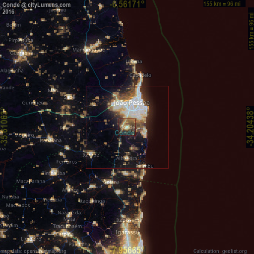
Analysis of Conde night lights 2016
Square area 10x10 km:
 0.22%
0.22%90-99
1.95%80-89
8.66%70-79
8.01%60-69
11.26%50-59
12.34%40-49
14.29%30-39
18.83%20-29
8.23%10-19
15.37%0-9
0.87%Square area 50x50 km:
3.73%90-99
4.08%80-89
3.58%70-79
1.57%60-69
2.18%50-59
3.26%40-49
3.51%30-39
3.28%20-29
5.02%10-19
10.52%0-9
59.26%Clear (daylight) street map image can be seen on geolist.org.
Map coordinates:
6° 33' 42.2" South, 35° 36' 38.3" West
7° 15' 35" South, 34° 54' 27" West
7° 57' 23.9" South, 34° 12' 15.8" West
Some cities around Conde sort by population:
• João Pessoa
16.8 km =10.4 mi,  16°
16°
• Santa Rita
18 km =11.2 mi,  334°
334°
• Bayeux
15.2 km =9.4 mi,  349°
349°
• Pedras de Fogo
27.9 km =17.3 mi,  235°
235°
• Caaporã
28.4 km =17.6 mi,  180°
180°
• Alhandra
19.9 km =12.4 mi, 182°
• Pitimbu
25.9 km =16.1 mi,  155°
155°
• Cruz do Espírito Santo
23.8 km =14.8 mi,  304°
304°
3385077 (p: 15,859)
Sources (retrieved 2019-11-25):
» Earth at Night: Flat Maps 2012, 2016