Condado night lights from space
Night Light of Condado (Pernambuco) from space (Brazil) Src. Average luminocity for 10x10km area is 15.6407% and for 50x50km: 12.5783%.
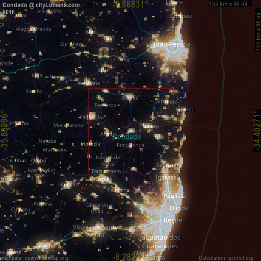
Analysis of Condado night lights 2016
Square area 10x10 km:
 0%
0%90-99
1.08%80-89
4.11%70-79
1.52%60-69
1.08%50-59
1.08%40-49
4.55%30-39
2.16%20-29
4.33%10-19
3.9%0-9
76.19%Square area 50x50 km:
0.41%90-99
0.83%80-89
2.7%70-79
1.07%60-69
1.23%50-59
2.11%40-49
2.48%30-39
2.21%20-29
2.96%10-19
11.34%0-9
72.65%Clear (daylight) street map image can be seen on geolist.org.
Map coordinates:
6° 53' 17.9" South, 35° 48' 32.3" West
7° 35' 9" South, 35° 6' 21" West
8° 16' 56" South, 34° 24' 9.8" West
Some cities around Condado sort by population:
• Timbaúba
25.1 km =15.6 mi,  290°
290°
• Goiana
11.7 km =7.3 mi,  76°
76°
• Nazaré da Mata
21.9 km =13.6 mi,  217°
217°
• Pedras de Fogo
20.5 km =12.7 mi,  356°
356°
• Caaporã
23.1 km =14.4 mi,  70°
70°
• Araçoiaba
22.8 km =14.2 mi,  175°
175°
• Itaquitinga
9.1 km =5.7 mi, 177°
• Vicência
25.6 km =15.9 mi,  252°
252°
3401830 (p: 19,585)
Sources (retrieved 2019-11-25):
» Earth at Night: Flat Maps 2012, 2016