Alhandra night lights from space
Night Light of Alhandra (Paraíba) from space (Brazil) Src. Average luminocity for 10x10km area is 20.6948% and for 50x50km: 13.8086%.
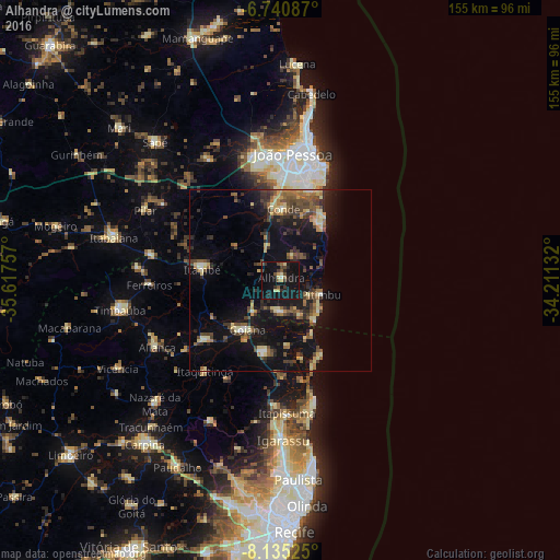
Analysis of Alhandra night lights 2016
Square area 10x10 km:
 0%
0%90-99
0.87%80-89
4.33%70-79
1.73%60-69
1.08%50-59
3.46%40-49
4.33%30-39
4.11%20-29
6.06%10-19
39.18%0-9
34.85%Square area 50x50 km:
0.31%90-99
0.68%80-89
2.73%70-79
1.36%60-69
1.86%50-59
2.58%40-49
3.23%30-39
2.81%20-29
3.29%10-19
14.98%0-9
66.19%Clear (daylight) street map image can be seen on geolist.org.
Map coordinates:
6° 44' 27.1" South, 35° 37' 3.3" West
7° 26' 19" South, 34° 54' 52" West
8° 8' 6.9" South, 34° 12' 40.8" West
Some cities around Alhandra sort by population:
• Bayeux
34.9 km =21.7 mi,  356°
356°
• Goiana
16.7 km =10.4 mi,  215°
215°
• Condado
26.7 km =16.6 mi,  232°
232°
• Conde
19.9 km =12.4 mi,  2°
2°
• Pedras de Fogo
22.6 km =14 mi,  280°
280°
• Caaporã
8.6 km =5.3 mi,  175°
175°
• Itaquitinga
32.8 km =20.4 mi, 219°
• Pitimbu
12.2 km =7.6 mi,  106°
106°
3407940 (p: 10,788)
Sources (retrieved 2019-11-25):
» Earth at Night: Flat Maps 2012, 2016