Piquete night lights from space
Night Light of Piquete (São Paulo) from space (Brazil) Src. Average luminocity for 10x10km area is 6.6705% and for 50x50km: 7.463%.
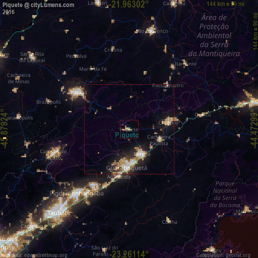
Analysis of Piquete night lights 2016
Square area 10x10 km:
 0.38%
0.38%90-99
0.38%80-89
0.95%70-79
1.7%60-69
2.65%50-59
1.52%40-49
0%30-39
0%20-29
0.76%10-19
0%0-9
91.67%Square area 50x50 km:
0.79%90-99
0.98%80-89
0.89%70-79
1.24%60-69
1.29%50-59
0.99%40-49
0.82%30-39
1%20-29
2.02%10-19
5.21%0-9
84.77%Clear (daylight) street map image can be seen on geolist.org.
Map coordinates:
21° 57' 46.9" South, 45° 52' 45.3" West
22° 36' 49" South, 45° 10' 34" West
23° 15' 40.1" South, 44° 28' 22.8" West
Some cities around Piquete sort by population:
• Guaratinguetá
22.6 km =14 mi,  184°
184°
• Itajubá
35.3 km =21.9 mi,  306°
306°
• Lorena
14.1 km =8.8 mi,  157°
157°
• Cruzeiro
21.5 km =13.4 mi,  77°
77°
• Campos do Jordão
44.8 km =27.8 mi,  251°
251°
• Aparecida
26.5 km =16.5 mi,  191°
191°
• Passa Quatro
32.9 km =20.4 mi,  40°
40°
• Itanhandu
43.2 km =26.8 mi, 35°
3453682 (p: 13,844)
Sources (retrieved 2019-11-25):
» Earth at Night: Flat Maps 2012, 2016