Otacílio Costa night lights from space
Night Light of Otacílio Costa (Santa Catarina) from space (Brazil) Src. Average luminocity for 10x10km area is 11.6806% and for 50x50km: 1.14%.
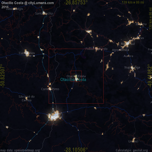
Analysis of Otacílio Costa night lights 2016
Square area 10x10 km:
 1.79%
1.79%90-99
1.39%80-89
0.79%70-79
1.39%60-69
3.37%50-59
3.17%40-49
1.19%30-39
0%20-29
0.79%10-19
0%0-9
86.11%Square area 50x50 km:
0.11%90-99
0.1%80-89
0.18%70-79
0.13%60-69
0.22%50-59
0.31%40-49
0.1%30-39
0.15%20-29
0.17%10-19
0.04%0-9
98.5%Clear (daylight) street map image can be seen on geolist.org.
Map coordinates:
26° 51' 27.1" South, 50° 49' 30.3" West
27° 28' 59" South, 50° 7' 19" West
28° 6' 18.2" South, 49° 25' 7.8" West
Some cities around Otacílio Costa sort by population:
• Lages
42.1 km =26.2 mi,  208°
208°
• Rio do Sul
56 km =34.8 mi,  57°
57°
• Curitibanos
50.8 km =31.6 mi,  295°
295°
• Ibirama
76.2 km =47.3 mi,  51°
51°
• São Joaquim
92.1 km =57.2 mi,  168°
168°
• Santa Cecília
65.4 km =40.6 mi,  332°
332°
• Correia Pinto
26.2 km =16.3 mi,  244°
244°
• Residencia Moacir PU5BHV
98.3 km =61.1 mi, 49°
3455750 (p: 14,557)
Sources (retrieved 2019-11-25):
» Earth at Night: Flat Maps 2012, 2016